Contour lines plugin — OsmAnd
4.8التقييم
Jun 25, 2024أحدث تحديث
1.0الإصدار
حول Contour lines plugin — OsmAnd
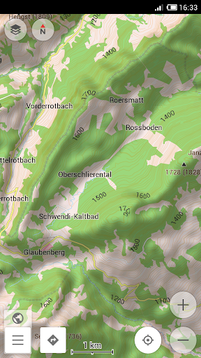
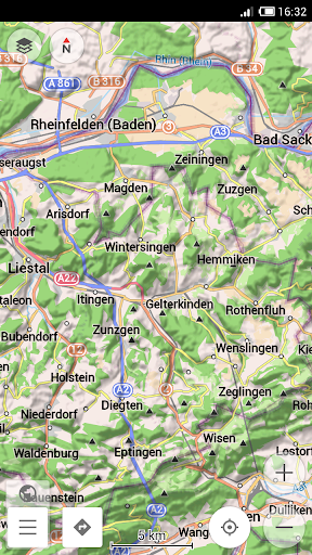
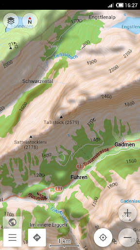
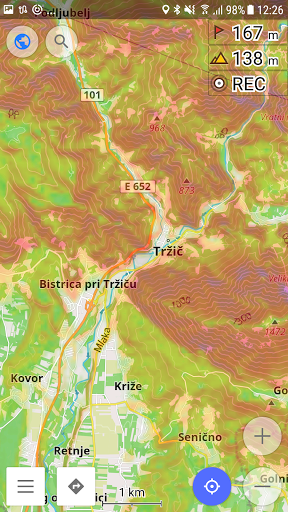
Contour lines plugin — OsmAnd is a plugin for 'Maps & Navigation — OsmAnd' app. The plugin provides extremely detailed offline topo maps that can be zoomed in and out without losing the quality. These topographic maps can also be complemented with a layer of 3D terrain representation ('hillshade'). Contour lines plugin — OsmAnd is a useful reference tool for hikers, tourists, cyclists, and any topography enthusiast.
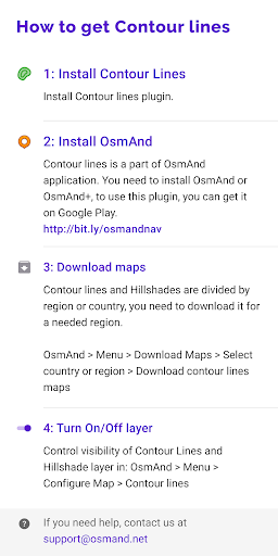
To download the contour lines and hillshade maps, please go to OsmAnd > Download maps > choose the country you need > Contour Lines/Hillshade.
You can enable this layer of information by activating the plugin in OsmAnd > 'Plugins' and also enabling OsmAnd > Configure map > Contour Lines/Hillshade layer.
The global data (between 70 degrees north and 70 degrees south) is based on measurements by SRTM (Shuttle Radar Topography Mission) and ASTER (Advanced Spaceborne Thermal Emission and Reflection Radiometer), an imaging instrument onboard Terra, the flagship satellite of NASA's Earth Observing System. ASTER is a cooperative effort between NASA, Japan's Ministry of Economy, Trade and Industry (METI), and Japan Space Systems (J-spacesystems).
صور Contour lines plugin — OsmAnd
الإصدارات القديمة من Contour lines plugin — OsmAnd


تطبيقات مشابهة لـ Contour lines plugin — OsmAnd
 Contour lines plugin — OsmAnd4.8
 Parking Plugin — OsmAnd4.3
 Ski Map Plugin — OsmAnd4.6
 Lines 98 -Color Lines- Line 984.8
 nbWatch Ultra Contour4.7
 Best Contour Powder Tutorial4.8
 EMOTIV Contour4.7
 OsmAnd — Maps & GPS Offline4.5
 OsmAnd Nightly4.7
 OsmAnd - Offline Maps and GPS Navigation4.7
 OsmAnd-map-sample4.8
 Nautical Charts — OsmAnd4.8
Contour lines plugin — OsmAnd FAQ
كيف يمكنني تحميل Contour lines plugin — OsmAnd من PGYER APK HUB؟
هل التطبيق Contour lines plugin — OsmAnd على PGYER APK HUB مجاني للتحميل؟
هل أحتاج إلى حساب لتحميل Contour lines plugin — OsmAnd من PGYER APK HUB؟
كيف يمكنني الإبلاغ عن مشكلة في Contour lines plugin — OsmAnd على PGYER APK HUB؟
هل وجدت هذا مفيداً؟
نعم
لا
آراء المستخدمين
+ المراجعات
4.8
5
4
3
2
1
C
Christine
2025-02-20
25
0
The Contour lines plugin — OsmAnd is an essential tool for hikers and outdoor enthusiasts. The detailed contour lines make navigation in remote areas a breeze!
J
Josie
2025-03-11
9
0
I absolutely love the Contour lines plugin — OsmAnd. It provides accurate elevation data that is crucial for my mountain biking adventures.
A
Amanda
2025-01-10
10
0
The Contour lines plugin — OsmAnd has transformed the way I plan my hiking trips. The contour lines are incredibly precise and easy to read.
الأكثر شهرة
InstaGold
Assem Mahgoob
4.8FuteMax
Omv
4.6KOPLO77
KOPLO77 APK - Comprehensive Overview
Discover the vibrant world of KOPLO77, an innovative applicatio
4.6Mega888
Mega888 APK - Ultimate Gaming Experience at Your Fingertips
Overview:
Discover the thrilling world o
4.6PRX XIT MOBILE PANEL
PRX XIT MOBILE PANEL - Comprehensive Overview
Introduction
Discover the PRX XIT MOBILE PANEL, a cutt
4.9BIGO LIVE Lite – Live Stream
Bigo Technology Pte. Ltd.
4.3PLN Mobile
P L N
4.7Microsoft Word: Edit Documents
Microsoft Corporation
4.6MiChat - Chat, Make Friends
MICHAT PTE. LIMITED
4.0WEBTOON
NAVER WEBTOON
4.6SuperFishing Casino- Slots 777
Joyous.games
4.6ChatGPT
OpenAI
4.8TippoParty
TippoParty
4.6WePlay(ويبلاي) - Game & Chat
WEJOY Pte. Ltd.
4.6HeeSay - Blued LIVE & Dating
iRainbow
4.1Max: Stream HBO, TV, & Movies
WarnerMedia Global Digital Services, LLC
4.7App Market
Oppo
4.6ENUYGUN
WINGIE ENUYGUN GROUP
4.7Kalos TV
Kalos_ShortTV
4.6Game Booster VIP Lag Fix & GFX
TOLAN
4.8999+ Gamebox
AyYıldız
4.8LostLife
Lost Life APK Download and Guide
Today, we're exploring Lost Life, a popular 3D simulation horror ga
4.9Naruto Senki
Naruto Senki APK is a mobile fighting game inspired by the popular Naruto anime and manga series. It
4.6GTA 6
RICHIEMANMARIO ALT
3.2