Mgrs & Utm Map Pro
Bewertung
Jun 19, 2024Neuestes Update
7.2Version
Über Mgrs & Utm Map Pro
Special features at pro version:
👉 More maps (Bicycle, Topographic, Neighborhood, Atlas etc.)
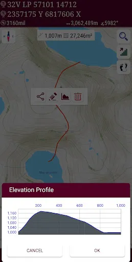
👉 You can see the altitude profile of your route on the chart
👉 You can search for locations by address
👉 You can create different layers for your different activities
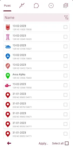
👉 List view for markers, routes, areas and KML
👉 You can draw multiple routes and areas, and change their colors
👉 More and colorful pointer icons
👉 Name or icon display options for markers
👉 Multiple routes can be recorded with the GPS recorder
👉 And no ads
This application is GPS and coordinate systems helper especially for military personnel.
It is also a complete helper for mountaineering, trekking and hiking, cross running, scouting, hunting, fishing, geocaching, off-road navigation and all other outdoor activities and sports.
With satellite navigation systems such as GPS, GALILEO and GLONASS (GNSS) supported by your device and your sensors, you can see your most accurate position on different map layers.
Features:
* Easy and Faster
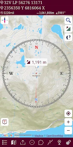
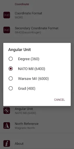
* Compass.
=> Compass on map (on the map that shows your direction)
=> Compass only (shows physical directions)
=> Angular units for compass (degrees, grad and mil)
* Follow Mode
=> The center of the map follows your location while on the move.
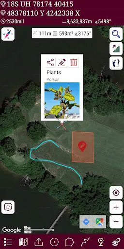
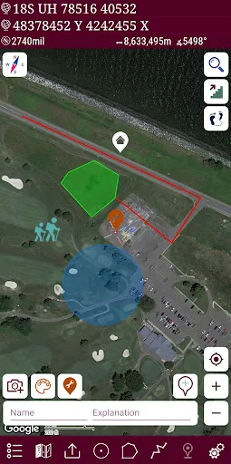
* You can add and removing markers.
* Distance measure. (You can add custom route and calculate total distance)
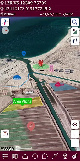
* Area measure.(You can select an area on the map and calculate the area in square meters)
* You can see the altitude of your location.
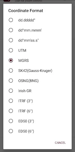
* You can find the location according to Address, Degree/Minute/Second , MGRS, UTM or Latitude/Longitude formats.
* Location (Coordinate) unit options.
=> MGRS / U.S. National Grid (USNG) (WGS84/NAD83)
=> D°M'S" (WGS84)
=> Latitude/Longitude (WGS84)
=> UTM (WGS84/NAD83)
=> SK42(Gauss Kruger)
=> British National Grid(OSNG)
=> Irish Grid Reference
=> ED50
=> ITRF
* Map type options (Road,Terrain,Satellite,Night Mode,Hybrid)
* You can share location coordinate.
* Distance unit options. (meter and feet).
* KML viewer. (Export and import KML layers).
👉 More maps (Bicycle, Topographic, Neighborhood, Atlas etc.)
👉 You can see the altitude profile of your route on the chart
👉 You can search for locations by address
👉 You can create different layers for your different activities
👉 List view for markers, routes, areas and KML
👉 You can draw multiple routes and areas, and change their colors
👉 More and colorful pointer icons
👉 Name or icon display options for markers
👉 Multiple routes can be recorded with the GPS recorder
👉 And no ads
This application is GPS and coordinate systems helper especially for military personnel.
It is also a complete helper for mountaineering, trekking and hiking, cross running, scouting, hunting, fishing, geocaching, off-road navigation and all other outdoor activities and sports.
With satellite navigation systems such as GPS, GALILEO and GLONASS (GNSS) supported by your device and your sensors, you can see your most accurate position on different map layers.
Features:
* Easy and Faster
* Compass.
=> Compass on map (on the map that shows your direction)
=> Compass only (shows physical directions)
=> Angular units for compass (degrees, grad and mil)
* Follow Mode
=> The center of the map follows your location while on the move.
* You can add and removing markers.
* Distance measure. (You can add custom route and calculate total distance)
* Area measure.(You can select an area on the map and calculate the area in square meters)
* You can see the altitude of your location.
* You can find the location according to Address, Degree/Minute/Second , MGRS, UTM or Latitude/Longitude formats.
* Location (Coordinate) unit options.
=> MGRS / U.S. National Grid (USNG) (WGS84/NAD83)
=> D°M'S" (WGS84)
=> Latitude/Longitude (WGS84)
=> UTM (WGS84/NAD83)
=> SK42(Gauss Kruger)
=> British National Grid(OSNG)
=> Irish Grid Reference
=> ED50
=> ITRF
* Map type options (Road,Terrain,Satellite,Night Mode,Hybrid)
* You can share location coordinate.
* Distance unit options. (meter and feet).
* KML viewer. (Export and import KML layers).
Mgrs & Utm Map Pro Screenshots
Alte Versionen von Mgrs & Utm Map Pro


Empfehlung des Herausgebers
Apps wie Mgrs & Utm Map Pro
Apps von DakikTech
Mgrs & Utm Map Pro FAQ
Wie lade ich Mgrs & Utm Map Pro von PGYER APK HUB herunter?
Ist das Mgrs & Utm Map Pro auf PGYER APK HUB kostenlos zum Download?
Benötige ich ein Konto, um Mgrs & Utm Map Pro von PGYER APK HUB herunterzuladen?
Wie kann ich ein Problem mit Mgrs & Utm Map Pro auf PGYER APK HUB melden?
Haben Sie dies hilfreich gefunden
Ja
Nein
Benutzerbewertungen
+ Bewertungen
4.7
5
4
3
2
1
R
Robinson
2025-01-22
23
0
Mgrs & Utm Map Pro is an incredibly useful tool for anyone who needs precise mapping and navigation. The interface is user-friendly and the features are top-notch!
P
Patrick
2025-03-01
4
0
Mgrs & Utm Map Pro is the best mapping app I’ve ever used. It’s packed with features and works seamlessly on my device.
W
Wendy
2024-12-17
4
0
I love how intuitive Mgrs & Utm Map Pro is. It’s perfect for both beginners and advanced users. Highly recommend!
Am beliebtesten
Hole.io
VOODOO
Super Mario Odyssey
Super Mario Odyssey APK - Explore the World Like Never Before!
Embark on an exhilarating adventure w
Plague Inc.
Ndemic Creations
StarMaker: Sing Karaoke Songs
SKYWORK AI PTE. LTD.
Poppo Live
Poppo Team
CookieRun: OvenBreak
Devsisters Corporation
Netflix
Netflix, Inc.
TikTok
TikTok Pte. Ltd.
Legend of Solgard
Snowprint Studios AB
X
X Corp.
Clash Royale
Supercell
Tips Dream League Soccer 2017
amorphisnguyen
Relic Bag: Shadow Hunter
Fansipan Limited
PUBG MOBILE
Level Infinite
Pure Sniper: Gun Shooter Games
Miniclip.com
War Thunder Mobile
GAIJIN NETWORK LTD
Off Road 4x4 Driving Simulator
Azur Interactive Games Limited
Call of Duty: Warzone Mobile
Activision Publishing, Inc.
GunboundM
DargomStudio
Car Parking Multiplayer 2
olzhass
Talking Pierre the Parrot
Outfit7 Limited
Red Dead redemption 2 Mobile
Tarik EL hamdi
Shadow Fight 2 Special Edition
NEKKI
Reddit
reddit Inc.