Measure Ground Control
4.0평점
Sep 27, 2023최신 업데이트
4.1.2버전
Measure Ground Control 정보
Measure Ground Control is an all-in-one drone deployment and data management software solution for UAV pilots, small businesses and large enterprises. Create a mission, plan a flight, check airspace, and process your image data in a variety of formats, such as high-quality orthomosaics, 3D maps and 3D mesh, thermal imagery, digital surface models (DSM), and many more. Manage your pilots and drone fleet, create and reuse flight plans, store and maintain fly sites, build flight schedules, run safety checklists and log flight data, as well as create customized data reports.
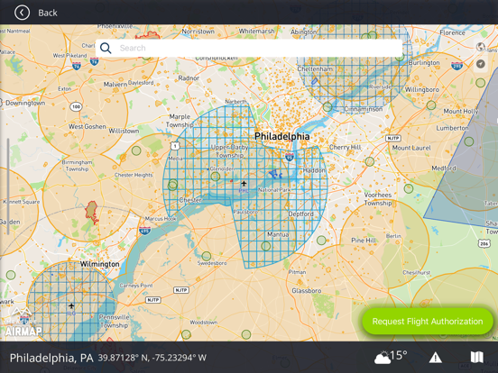
With the ability to navigate seamlessly between the web and mobile applications, Measure Ground Control features LAANC airspace authorization with built-in Airmap technology, so you can fly any airspace safely within FAA compliant. Process and create data products with our advanced photogrammetry and image processing featuring an integrated Pix4D toolkit, or inspect and annotate image data using our custom Scopito integration, all within the convenience of a single software application.
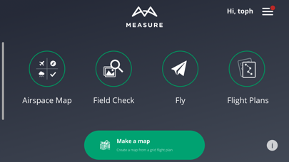
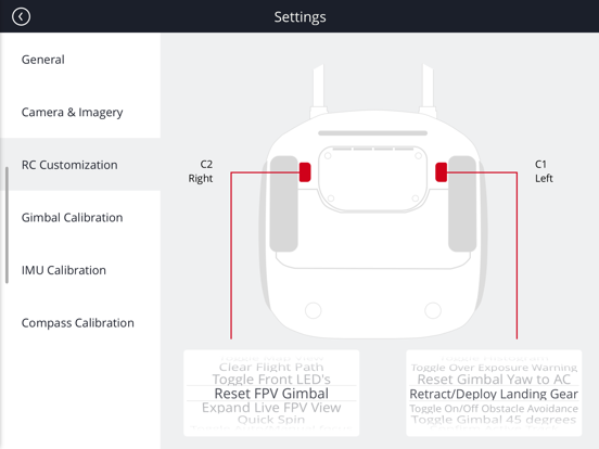
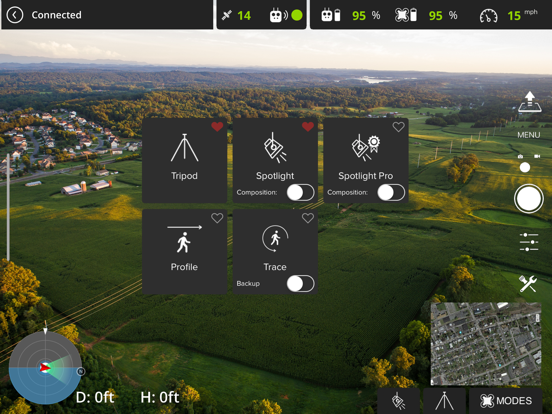
Measure Ground Control offers multiple flight modes including Panorama, Spotlight, POI, Profile, Trace, and Tripod. Additional features can be activated for Enterprise users. Built for universal DJI compatibility.
Device Compatibility
iPhone (6s, 6s+, 7, 7+, 8, 8+, X, XS, XS Max, XR 11, 11 Pro, 11 Pro Max, 12, 12 mini, 12 Pro, 12 Pro Max), iPhone SE (1st , 2nd gen), iPad Air (2nd, 3rd, 4th gen), iPad mini (4th, 5th gen), iPad Pro (1st, 2nd, 3rd, 4th gen), iPad (5th, 6th, 7th, 8th gen)
Highlights
Manual flight mode with live streaming
Grid flight mode with terrain follow
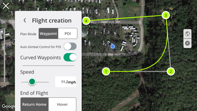
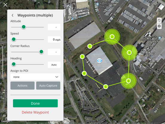
Custom waypoint flight plans
Mission creation and management
Drone fleet & pilot management
Image data processing & custom reports
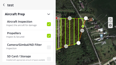
Custom flight safety checklists
LAANC digital authorization request
Flight logs & realtime flight info
DJI Compatibility
• Mavic (all versions)
• Mavic 2 (all versions) including Smart Controller*
• Mavic Air 1
• Phantom 3 (all versions)
• Phantom 4 (all versions)
• Exception being the P4P RTK and Multispectral - limited functionality
• Inspire 1, 1 Pro and Inspire 2
• Matrice 100/200/210 (all versions)
• Matrice 600 and 600 Pro
• Mavic Mini*
• Spark*
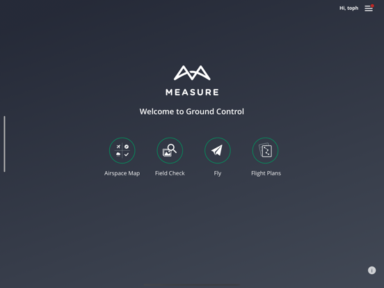
Plan a Mission
Schedule and manage mission calendar
Assign pilots and equipment and send notifications
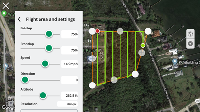
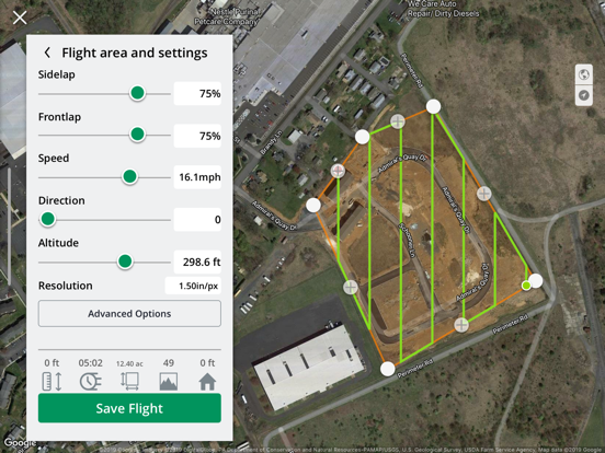
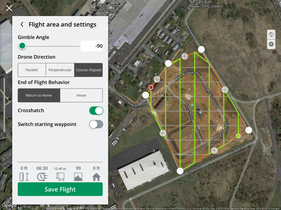
Create a flight plan with a KML file, grid or waypoint plan
Sync flight plans to the mobile flight app
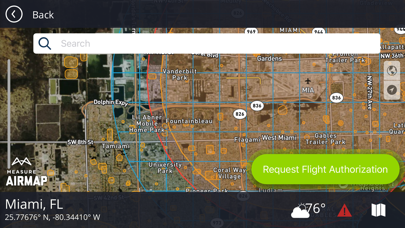
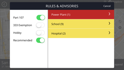
Check airspace and weather
Fly & Collect Data
Request LAANC authorization
Retrieve and apply DJI Geo Unlock
Fly with GPS-aided manual control, automated grid and waypoint patterns
Use active track modes including spotlight, POI, trace, orbit and profile
Automatically upload flight logs and screen captures
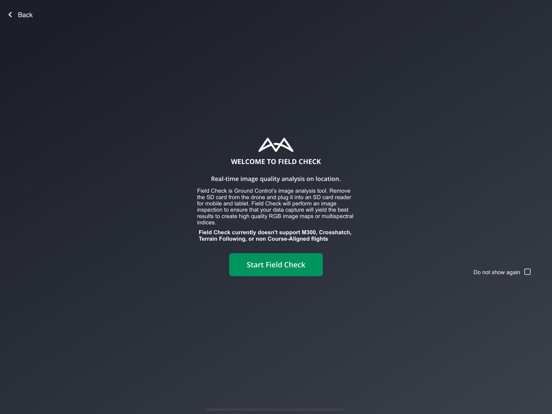
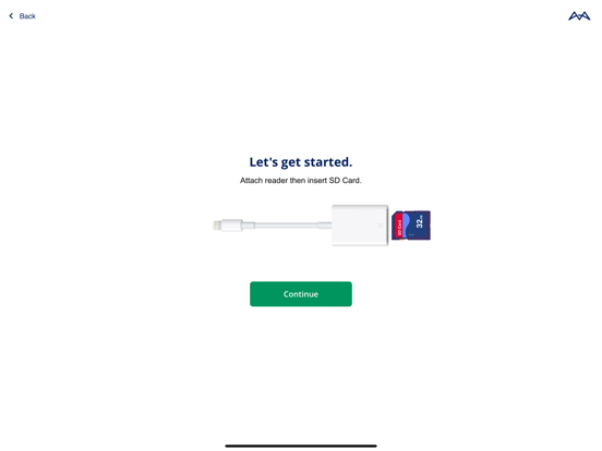
Process & Analyze*
Process imagery into high-quality data products powered by Pix4D
Increase image processing accuracy with RTK drone data, or use GCPs info
Create orthomosaics, point clouds, digital surface models, and contour maps
Measure linear distance and area or add a 2D layers to your map
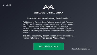
Analyze data with our integrated Scopito annotation tool
Report and Store Data*
Store unlimited flight logs, imagery, video, and uploaded files
Track activity and compliance with built-in reports
Export and share data products (orthos, DSM, contours) as GeoTIFF or GeoJSON files
Add inspection results and review mission and portfolio-level summaries
Upload completed data products to each mission
Manage Operations*
Access automatically uploaded flight logs, including flight playback and screen captures
Check automatically flagged incidents for activity outside of safety best practices
Add users, setup user profiles, control user permissions with pre-defined roles
Manage equipment with automatic usage tracking
Track program activity with dashboards and exportable PDF and CSV reports
*Some functionality might not be fully supported.
With the ability to navigate seamlessly between the web and mobile applications, Measure Ground Control features LAANC airspace authorization with built-in Airmap technology, so you can fly any airspace safely within FAA compliant. Process and create data products with our advanced photogrammetry and image processing featuring an integrated Pix4D toolkit, or inspect and annotate image data using our custom Scopito integration, all within the convenience of a single software application.
Measure Ground Control offers multiple flight modes including Panorama, Spotlight, POI, Profile, Trace, and Tripod. Additional features can be activated for Enterprise users. Built for universal DJI compatibility.
Device Compatibility
iPhone (6s, 6s+, 7, 7+, 8, 8+, X, XS, XS Max, XR 11, 11 Pro, 11 Pro Max, 12, 12 mini, 12 Pro, 12 Pro Max), iPhone SE (1st , 2nd gen), iPad Air (2nd, 3rd, 4th gen), iPad mini (4th, 5th gen), iPad Pro (1st, 2nd, 3rd, 4th gen), iPad (5th, 6th, 7th, 8th gen)
Highlights
Manual flight mode with live streaming
Grid flight mode with terrain follow
Custom waypoint flight plans
Mission creation and management
Drone fleet & pilot management
Image data processing & custom reports
Custom flight safety checklists
LAANC digital authorization request
Flight logs & realtime flight info
DJI Compatibility
• Mavic (all versions)
• Mavic 2 (all versions) including Smart Controller*
• Mavic Air 1
• Phantom 3 (all versions)
• Phantom 4 (all versions)
• Exception being the P4P RTK and Multispectral - limited functionality
• Inspire 1, 1 Pro and Inspire 2
• Matrice 100/200/210 (all versions)
• Matrice 600 and 600 Pro
• Mavic Mini*
• Spark*
Plan a Mission
Schedule and manage mission calendar
Assign pilots and equipment and send notifications
Create a flight plan with a KML file, grid or waypoint plan
Sync flight plans to the mobile flight app
Check airspace and weather
Fly & Collect Data
Request LAANC authorization
Retrieve and apply DJI Geo Unlock
Fly with GPS-aided manual control, automated grid and waypoint patterns
Use active track modes including spotlight, POI, trace, orbit and profile
Automatically upload flight logs and screen captures
Process & Analyze*
Process imagery into high-quality data products powered by Pix4D
Increase image processing accuracy with RTK drone data, or use GCPs info
Create orthomosaics, point clouds, digital surface models, and contour maps
Measure linear distance and area or add a 2D layers to your map
Analyze data with our integrated Scopito annotation tool
Report and Store Data*
Store unlimited flight logs, imagery, video, and uploaded files
Track activity and compliance with built-in reports
Export and share data products (orthos, DSM, contours) as GeoTIFF or GeoJSON files
Add inspection results and review mission and portfolio-level summaries
Upload completed data products to each mission
Manage Operations*
Access automatically uploaded flight logs, including flight playback and screen captures
Check automatically flagged incidents for activity outside of safety best practices
Add users, setup user profiles, control user permissions with pre-defined roles
Manage equipment with automatic usage tracking
Track program activity with dashboards and exportable PDF and CSV reports
*Some functionality might not be fully supported.
Measure Ground Control 스크린샷
Measure Ground Control iPad 스크린샷


Measure Ground Control와 비슷한 앱
 Measure Ground Control4.0
 Digging Ground Measure A Hole-
 Measure - learn Mandarin Chinese measure words in this simple game3.0
 AR Tape Measure: Air Measure2.1
 Ruler-AR Measure&Tape Measure-
 Measure.Me: Measure body size-
 Smart Measure-Measure with Cam-
 Measure a Lot - Lot Measure-
 Ground Control SOMA-
 Ground Control-
 Ground Control MD-
 RIVA Turbo X Ground Control1.6
가장 인기 있는
Sing It - Ear TrainerA must app for every musician, singer, or just for fun.
Test,train, and improve your musical ear an
Tube PiP - PiP for YouTubeTube PiP - the ultimate YouTube companion for iOS:
1. Picture in Picture (PiP) Playback: Watch YouT
Papaya Ouch!In the game Papaya Ouch!, you can experience backpack management, tower defense, TD, merge, match 2,
Lets Go VPNLets Go VPN, the most advanced VPN, is designed by a team of top developers who strive to ensure all
Paprika Recipe Manager 3Organize your recipes. Create grocery lists. Plan your meals. Download recipes from your favorite we
War Pigeons UnboundedWar is coming. Deep down in top secret military labs they have evolved, mutated - and escaped. The f
Procreate PocketApp of the Year winner Procreate Pocket is the most feature-packed and versatile art app ever design
Cowboy Westland survival runAre you ready to take part in the #1 exciting 3D western adventure? Cowboy Westland survival run mak
Max: Stream HBO, TV, & MoviesIt’s all here. Iconic series, award-winning movies, fresh originals, and family favorites, featuring
TonalEnergy Tuner & MetronomeFor musicians from pros to beginners, whether you sing, play a brass, woodwind or stringed instrumen
SkyView®SkyView® brings stargazing to everyone. Simply point your iPhone, iPad, or iPod at the sky to identi
Ninja Dash 2015Ninja Dash 2015 is the fast paced running game!<br>On these maze fields, rush to the end of this nin
Tami-Live Chat&VideoTami is an app that records daily life and ideas.<br><br>You can use it to record your every day, wh
SALE Camera - marketing camera effects plus photo editorSALE Camera Help you create the best Business to consumer Stock Photos and Images. provides 300 filt
DevTutor for SwiftUI"DevTutor" is an application designed to assist developers in creating exceptional apps using SwiftU
Mokens League SoccerDive into Mokens League Soccer and experience the new era of soccer gaming!
Esports for Everyone: W
Zombie ZZOMBIE ENDLESS RUNNER LIKES NO OTHER!<br><br>WHY?<br><br>* Awesome graphic quality!<br><br>* Simplif
Dead Z - Zombie SurvivalCatastrophic explosion at the Omega Labs started the apocalypse, now spreading across the Earth.
Ta
HotSchedulesHotSchedules is the industry's leading employee scheduling app because it’s the fastest and easiest
ChatGPTIntroducing ChatGPT for iOS: OpenAI’s latest advancements at your fingertips.
This official app is
Disney StoreDisney Store is your official home for exclusive collections, designer collaborations, and one-of-a-
fight back tennisa Pong game with Tennis style, the gameplay itself is very simple, you can using Touch. Ball speed w
Dr. Mina AdlyMina Adly mobile app provides students with portable instant access to a selection of services.
Usi
iVerify BasiciVerify Basic is your gateway to enhanced device security and threat awareness, offering a glimpse i