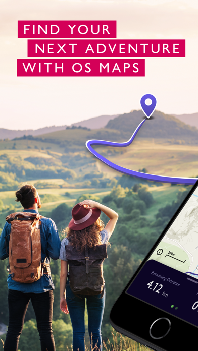
OS Maps: Walk, Hike, Run, Bike
4.7评分
Nov 06, 2024最近更新
5.3.0版本
关于OS Maps: Walk, Hike, Run, Bike
Create your adventures your way & let OS Maps guide you on stunning routes across the UK & beyond. Get more from the outdoors, with more freedom to explore, more confidence to tackle that next challenge & more adventures along the way. OS Maps is the official app by Ordnance Survey & your guide in the great outdoors.
Why you’ll love using OS Maps:
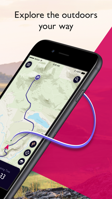
EXPLORE & PLAN HIKES, RUNS OR RIDES
Whether you are planning a walk, hike, run or ride; OS Maps lets you create outdoor adventures with trusted mapping & navigation tools from the experts at Ordnance Survey, Britain’s national mapping service.
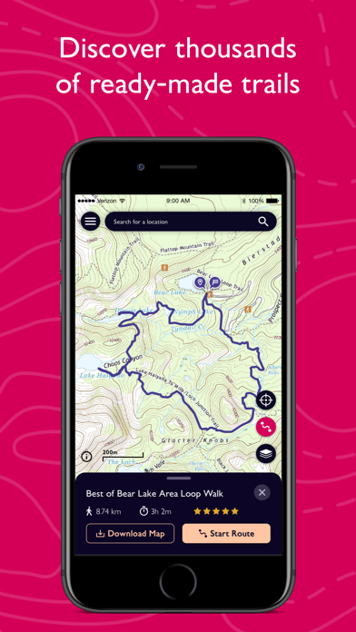
DISCOVER THOUSANDS OF READY-MADE ROUTES
Get outside with curated routes from outdoor experts & organisations such as Trail, Country Walking, Mountain Bike UK, BBC Countryfile & more.
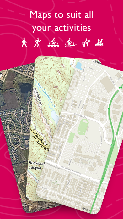
ICONIC OS MAPPING
Subscribe to unlock the detail & accuracy of OS leisure maps including OS Explorer 1:25,000 & OS Landranger 1:50,000 & now with global mapping & topographic mapping for USA, Australia & New Zealand to keep you exploring all over the world.
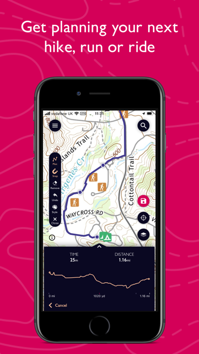
CREATE YOUR OWN ADVENTURES
Best in class route planning & navigation tools mean you can get off the beaten track & explore with more freedom. Plan routes with quick & easy snap-to-path route plotting, then save & share with your friends to plan that next epic day in the outdoors.
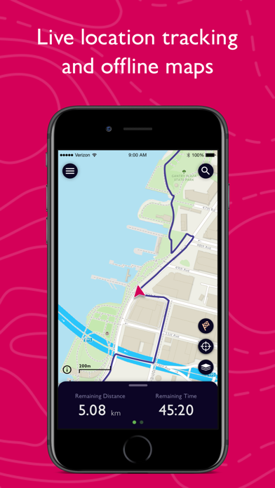
NO SIGNAL? NO PROBLEM
Download maps & routes to your phone to view offline, so they’re ready, whenever & wherever you need them. View any part of GB even without signal & export to your GPS device.
UNLIMITED PRINTING
Print copies of all your routes & maps to take with you, so you always have a backup to hand.
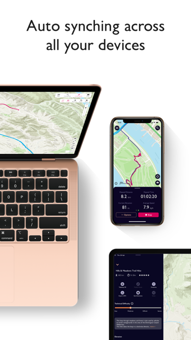
USE ON EVERY DEVICE
Sync your activities between across devices, on desktop, mobile & Apple Watch. On desktop, premium users can use our 3D Aerial Layer & route fly-throughs to see the landscape, terrain & explore in stunning 3D.
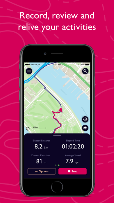
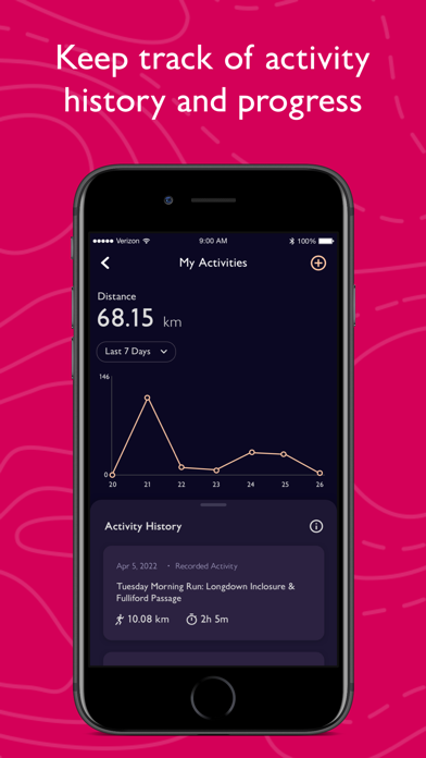
TRACK & RECORD ACTIVITIES
Use the activity recording feature to keep a log of your activity history. Follow along, save your activity, review it & turn it into a new route to share & follow again later.
RECOMMENDED BY THE EXPERTS
Ordnance Survey is proud to partner with Mountain Rescue England & Wales, with OS Maps as their recommended app to help you keep on track, & keep safe when heading outside.
TABLETOP 3D
Preview a route before you tackle it, ensure it’s suitable for your level of fitness & avoid any surprises. Our 3D model feature lets you check out your routes from the comfort of your home.
SUBSCRIPTION INFORMATION
OS Maps premium is available through a 1 month or 1 year subscription. Prices are posted in GBP but may vary by country or when converted to local currency. Subscriptions will auto-renew. Payment will be charged to iTunes Account at confirmation of purchase. The subscription automatically renews unless auto-renew is turned off at least 24-hours before the end of the current period. Your account will be charged for renewal within 24-hours prior to the end of the current period, & identify the cost of the renewal. Subscriptions may be managed by the user & auto-renewal may be turned off by going to the user's Account Settings after purchase.
Terms & Conditions at os.uk/termsosmaps
USEFUL INFORMATION
Battery life while using the app can be extended downloading maps offline prior to use, operating in Flight Mode (the GPS will still work) & turning off the screen when not in use. We release updates to all of our apps on an ongoing basis to improve stability & add extra features. Topographic mapping is available for UK (including Northern Ireland), USA, Australia & New Zealand. Your feedback & comments about this app are important to us. Leave a review or use os.uk/contact to get in touch.
*This feature uses Apple's ARKit which requires an iPhone 6s, iPhone SE, iPad 2017, iPad Pro or any later device.
Why you’ll love using OS Maps:
EXPLORE & PLAN HIKES, RUNS OR RIDES
Whether you are planning a walk, hike, run or ride; OS Maps lets you create outdoor adventures with trusted mapping & navigation tools from the experts at Ordnance Survey, Britain’s national mapping service.
DISCOVER THOUSANDS OF READY-MADE ROUTES
Get outside with curated routes from outdoor experts & organisations such as Trail, Country Walking, Mountain Bike UK, BBC Countryfile & more.
ICONIC OS MAPPING
Subscribe to unlock the detail & accuracy of OS leisure maps including OS Explorer 1:25,000 & OS Landranger 1:50,000 & now with global mapping & topographic mapping for USA, Australia & New Zealand to keep you exploring all over the world.
CREATE YOUR OWN ADVENTURES
Best in class route planning & navigation tools mean you can get off the beaten track & explore with more freedom. Plan routes with quick & easy snap-to-path route plotting, then save & share with your friends to plan that next epic day in the outdoors.
NO SIGNAL? NO PROBLEM
Download maps & routes to your phone to view offline, so they’re ready, whenever & wherever you need them. View any part of GB even without signal & export to your GPS device.
UNLIMITED PRINTING
Print copies of all your routes & maps to take with you, so you always have a backup to hand.
USE ON EVERY DEVICE
Sync your activities between across devices, on desktop, mobile & Apple Watch. On desktop, premium users can use our 3D Aerial Layer & route fly-throughs to see the landscape, terrain & explore in stunning 3D.
TRACK & RECORD ACTIVITIES
Use the activity recording feature to keep a log of your activity history. Follow along, save your activity, review it & turn it into a new route to share & follow again later.
RECOMMENDED BY THE EXPERTS
Ordnance Survey is proud to partner with Mountain Rescue England & Wales, with OS Maps as their recommended app to help you keep on track, & keep safe when heading outside.
TABLETOP 3D
Preview a route before you tackle it, ensure it’s suitable for your level of fitness & avoid any surprises. Our 3D model feature lets you check out your routes from the comfort of your home.
SUBSCRIPTION INFORMATION
OS Maps premium is available through a 1 month or 1 year subscription. Prices are posted in GBP but may vary by country or when converted to local currency. Subscriptions will auto-renew. Payment will be charged to iTunes Account at confirmation of purchase. The subscription automatically renews unless auto-renew is turned off at least 24-hours before the end of the current period. Your account will be charged for renewal within 24-hours prior to the end of the current period, & identify the cost of the renewal. Subscriptions may be managed by the user & auto-renewal may be turned off by going to the user's Account Settings after purchase.
Terms & Conditions at os.uk/termsosmaps
USEFUL INFORMATION
Battery life while using the app can be extended downloading maps offline prior to use, operating in Flight Mode (the GPS will still work) & turning off the screen when not in use. We release updates to all of our apps on an ongoing basis to improve stability & add extra features. Topographic mapping is available for UK (including Northern Ireland), USA, Australia & New Zealand. Your feedback & comments about this app are important to us. Leave a review or use os.uk/contact to get in touch.
*This feature uses Apple's ARKit which requires an iPhone 6s, iPhone SE, iPad 2017, iPad Pro or any later device.
OS Maps: Walk, Hike, Run, Bike应用截图


类似OS Maps: Walk, Hike, Run, Bike的应用
 OS Maps: Walk, Hike, Run, Bike4.7
 UCRoute: Walk, Run, Hike, Bike-
 Ireland Walk Hike Bike App-
 ViewRanger: Hike, Bike or Walk-
 Ireland Walk Hike Bike-
![Hike+ [hike more]](https://assets.appmeme.com/com.worldchamptech.coolhikeapp--ipa-1_5_9-icon.webp?x-oss-process=image/resize,w_51/format,webp) Hike+ [hike more]-
Hike+ [hike more]- Maps 3D - Hike & Bike4.3
 Maps 3D PRO - Hike & Bike4.4
 Trails.com: Hike, Walk and Run-
 komoot - hike, bike & run4.7
 Hikingbook: Hike, Bike & Run4.5
 Virtual Run, Bike & Hike3.0
最受欢迎
Sing It - Ear TrainerA must app for every musician, singer, or just for fun.
Test,train, and improve your musical ear an
Tube PiP - PiP for YouTubeTube PiP - the ultimate YouTube companion for iOS:
1. Picture in Picture (PiP) Playback: Watch YouT
Papaya Ouch!In the game Papaya Ouch!, you can experience backpack management, tower defense, TD, merge, match 2,
Lets Go VPNLets Go VPN, the most advanced VPN, is designed by a team of top developers who strive to ensure all
Paprika Recipe Manager 3Organize your recipes. Create grocery lists. Plan your meals. Download recipes from your favorite we
War Pigeons UnboundedWar is coming. Deep down in top secret military labs they have evolved, mutated - and escaped. The f
Procreate PocketApp of the Year winner Procreate Pocket is the most feature-packed and versatile art app ever design
Cowboy Westland survival runAre you ready to take part in the #1 exciting 3D western adventure? Cowboy Westland survival run mak
Max: Stream HBO, TV, & MoviesIt’s all here. Iconic series, award-winning movies, fresh originals, and family favorites, featuring
TonalEnergy Tuner & MetronomeFor musicians from pros to beginners, whether you sing, play a brass, woodwind or stringed instrumen
SkyView®SkyView® brings stargazing to everyone. Simply point your iPhone, iPad, or iPod at the sky to identi
Ninja Dash 2015Ninja Dash 2015 is the fast paced running game!<br>On these maze fields, rush to the end of this nin
Tami-Live Chat&VideoTami is an app that records daily life and ideas.<br><br>You can use it to record your every day, wh
SALE Camera - marketing camera effects plus photo editorSALE Camera Help you create the best Business to consumer Stock Photos and Images. provides 300 filt
DevTutor for SwiftUI"DevTutor" is an application designed to assist developers in creating exceptional apps using SwiftU
Mokens League SoccerDive into Mokens League Soccer and experience the new era of soccer gaming!
Esports for Everyone: W
Zombie ZZOMBIE ENDLESS RUNNER LIKES NO OTHER!<br><br>WHY?<br><br>* Awesome graphic quality!<br><br>* Simplif
Dead Z - Zombie SurvivalCatastrophic explosion at the Omega Labs started the apocalypse, now spreading across the Earth.
Ta
HotSchedulesHotSchedules is the industry's leading employee scheduling app because it’s the fastest and easiest
ChatGPTIntroducing ChatGPT for iOS: OpenAI’s latest advancements at your fingertips.
This official app is
Disney StoreDisney Store is your official home for exclusive collections, designer collaborations, and one-of-a-
fight back tennisa Pong game with Tennis style, the gameplay itself is very simple, you can using Touch. Ball speed w
Dr. Mina AdlyMina Adly mobile app provides students with portable instant access to a selection of services.
Usi
iVerify BasiciVerify Basic is your gateway to enhanced device security and threat awareness, offering a glimpse i