PointPlot
5Penilaian
Nov 16, 2018Kemas kini terkini
3.2.1Versi
Tentang PointPlot
PointPlot uses the GPS capability of an iOS device to make it simple to plot outdoor spaces and display this on a map and export to a variety of mapping systems, or share with others.
It is for anybody who has a need to record a real life location on a map or compare locations on a map back to real life. This could be farmers, builders, scientists, archaeologists, systems developers or anybody with an interest in maps.
At a glance:
+ Use your position on the ground to mark areas of a map
+ Use the app to perform length and area calculations of your survey
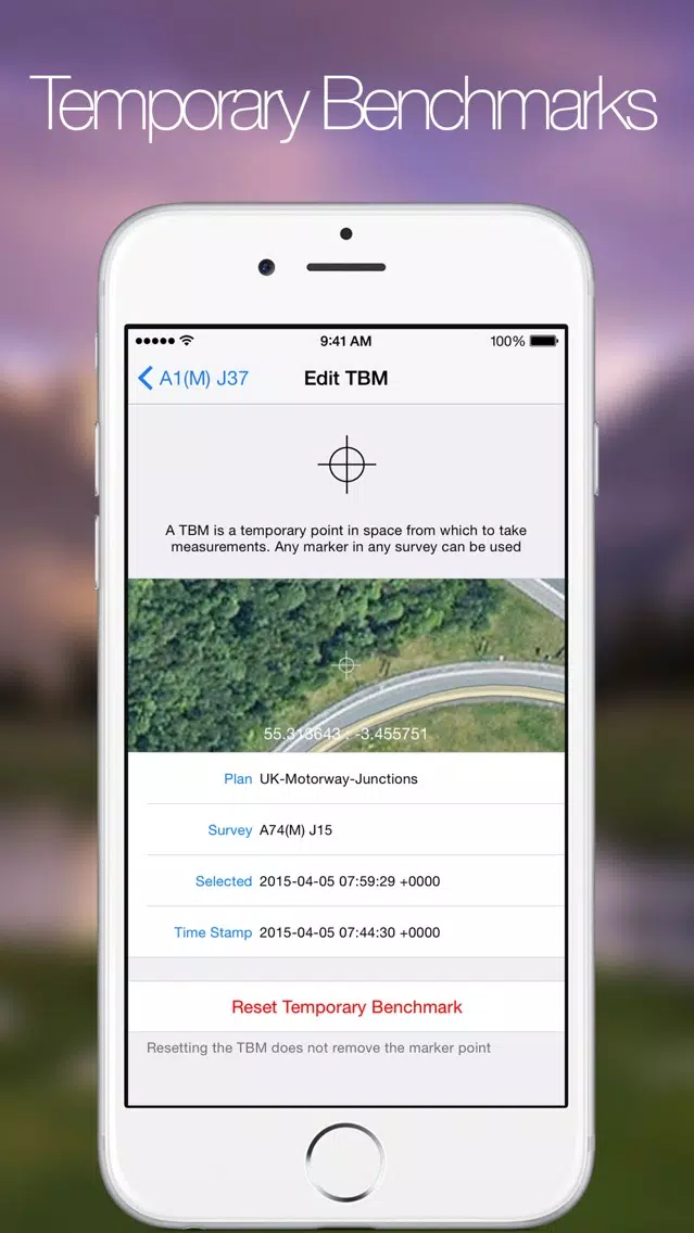
+ Use points on a map, or temporary benchmark, to mark out positions 'on the ground' from distance and bearings
+ Photograph the area and export photos to the device camera roll with coordinates watermark
+ Search for locations by address, coordinates or for UK locations OS Grid references
+ Multiple users and their devices can combine and work collaboratively to speed up large surveys
+ Share this information with others
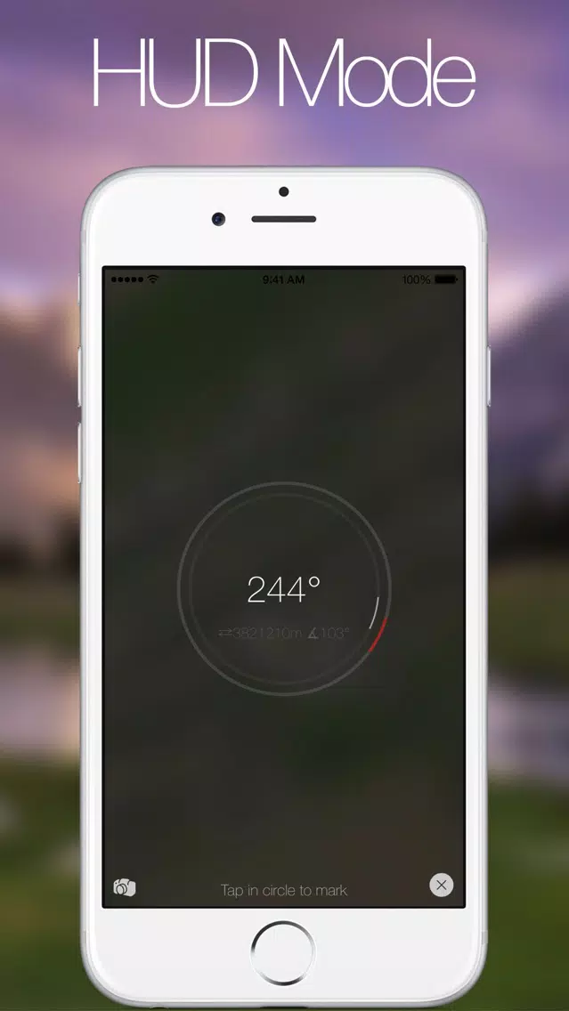
PointPlot also shows the users location in relation to the survey making it possible to make virtual boundaries and perimeters, for example to mark out a physical boundary where is is difficult or not possible to remain within line of sight of marker posts. The app also allows for the creation of temporary benchmarks, displaying the bearing and distance of the user from the point in a simplified 'Head Up Display' mode.
HUD mode simplifies the display, only showing the most relevant information and providing one large button to mark a point, ideal when working outside.
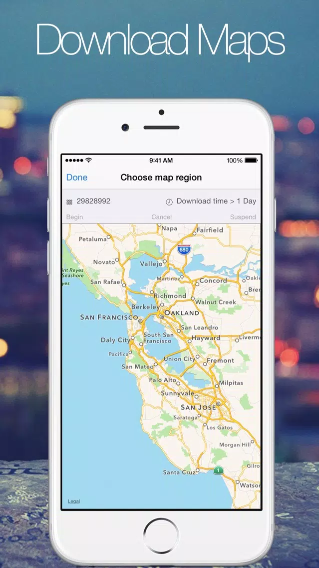
A plan is made up of multiple surveys. Each survey then maps out a portion of real ground according to a set of GPS coordinates. Surveys can be lines, polygons or even other shapes such as arcs. Surveys can be overlaid with geo-referenced images to add detail to satellite data.
Individual points can be adjusted with high accuracy or whole surveys can be simplified or straightened out automatically by the app.
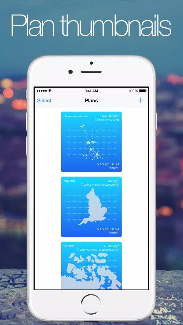
Plans are color coded depending on how many different types of survey they contain and each plan displays length and area calculations. Each individual survey also includes length and area calculations.
For larger surveys, such as those mapped out in a vehicle the app provides and auto mode. Once auto mode is started the screen can be locked to save battery life and the app records your location as you move, making it simple to plot large areas.
The app provides a built in camera display for taking photos of and around surveys. The camera displays location information as well as bearing and distance from temporary benchmark, making it easy to record photos of features from a variety of angles.
Once plans are complete they can be shared with any AirDrop compatible device or packaged up into an email. Plans can be exported as KML, GeoJSON, GPX or native format.
In addition surveys can be shared with nearby PointPlot users, even without internet coverage or cell signal. PointPlot makes use of the Multipeer Connectivity framework to create a mesh network, using wifi or bluetooth, making it easy to pass surveys between up to 8 devices at once.
Disclaimer:
PointPlot uses a background mode to continue to map out surveys when the screen is locked. This happens when 'auto mode' is selected.
Please note
"Continued use of GPS running in the background can dramatically decrease battery life."
It is for anybody who has a need to record a real life location on a map or compare locations on a map back to real life. This could be farmers, builders, scientists, archaeologists, systems developers or anybody with an interest in maps.
At a glance:
+ Use your position on the ground to mark areas of a map
+ Use the app to perform length and area calculations of your survey
+ Use points on a map, or temporary benchmark, to mark out positions 'on the ground' from distance and bearings
+ Photograph the area and export photos to the device camera roll with coordinates watermark
+ Search for locations by address, coordinates or for UK locations OS Grid references
+ Multiple users and their devices can combine and work collaboratively to speed up large surveys
+ Share this information with others
PointPlot also shows the users location in relation to the survey making it possible to make virtual boundaries and perimeters, for example to mark out a physical boundary where is is difficult or not possible to remain within line of sight of marker posts. The app also allows for the creation of temporary benchmarks, displaying the bearing and distance of the user from the point in a simplified 'Head Up Display' mode.
HUD mode simplifies the display, only showing the most relevant information and providing one large button to mark a point, ideal when working outside.
A plan is made up of multiple surveys. Each survey then maps out a portion of real ground according to a set of GPS coordinates. Surveys can be lines, polygons or even other shapes such as arcs. Surveys can be overlaid with geo-referenced images to add detail to satellite data.
Individual points can be adjusted with high accuracy or whole surveys can be simplified or straightened out automatically by the app.
Plans are color coded depending on how many different types of survey they contain and each plan displays length and area calculations. Each individual survey also includes length and area calculations.
For larger surveys, such as those mapped out in a vehicle the app provides and auto mode. Once auto mode is started the screen can be locked to save battery life and the app records your location as you move, making it simple to plot large areas.
The app provides a built in camera display for taking photos of and around surveys. The camera displays location information as well as bearing and distance from temporary benchmark, making it easy to record photos of features from a variety of angles.
Once plans are complete they can be shared with any AirDrop compatible device or packaged up into an email. Plans can be exported as KML, GeoJSON, GPX or native format.
In addition surveys can be shared with nearby PointPlot users, even without internet coverage or cell signal. PointPlot makes use of the Multipeer Connectivity framework to create a mesh network, using wifi or bluetooth, making it easy to pass surveys between up to 8 devices at once.
Disclaimer:
PointPlot uses a background mode to continue to map out surveys when the screen is locked. This happens when 'auto mode' is selected.
Please note
"Continued use of GPS running in the background can dramatically decrease battery life."
Tangkapan skrin PointPlot


PointPlot FAQ
Bagaimana saya boleh memuat turun PointPlot dari PGYER IPA HUB?
Adakah PointPlot di PGYER IPA HUB percuma untuk dimuat turun?
Adakah saya perlu akaun untuk memuat turun PointPlot dari PGYER IPA HUB?
Bagaimana saya boleh melaporkan masalah dengan PointPlot di PGYER IPA HUB?
Adakah anda dapati ini membantu
Ya
Tidak
Paling Popular
Sing It - Ear TrainerA must app for every musician, singer, or just for fun.
Test,train, and improve your musical ear an
Tube PiP - PiP for YouTubeTube PiP - the ultimate YouTube companion for iOS:
1. Picture in Picture (PiP) Playback: Watch YouT
Papaya Ouch!In the game Papaya Ouch!, you can experience backpack management, tower defense, TD, merge, match 2,
Lets Go VPNLets Go VPN, the most advanced VPN, is designed by a team of top developers who strive to ensure all
Paprika Recipe Manager 3Organize your recipes. Create grocery lists. Plan your meals. Download recipes from your favorite we
War Pigeons UnboundedWar is coming. Deep down in top secret military labs they have evolved, mutated - and escaped. The f
Procreate PocketApp of the Year winner Procreate Pocket is the most feature-packed and versatile art app ever design
Cowboy Westland survival runAre you ready to take part in the #1 exciting 3D western adventure? Cowboy Westland survival run mak
Max: Stream HBO, TV, & MoviesIt’s all here. Iconic series, award-winning movies, fresh originals, and family favorites, featuring
TonalEnergy Tuner & MetronomeFor musicians from pros to beginners, whether you sing, play a brass, woodwind or stringed instrumen
SkyView®SkyView® brings stargazing to everyone. Simply point your iPhone, iPad, or iPod at the sky to identi
Ninja Dash 2015Ninja Dash 2015 is the fast paced running game!<br>On these maze fields, rush to the end of this nin
Tami-Live Chat&VideoTami is an app that records daily life and ideas.<br><br>You can use it to record your every day, wh
SALE Camera - marketing camera effects plus photo editorSALE Camera Help you create the best Business to consumer Stock Photos and Images. provides 300 filt
DevTutor for SwiftUI"DevTutor" is an application designed to assist developers in creating exceptional apps using SwiftU
Mokens League SoccerDive into Mokens League Soccer and experience the new era of soccer gaming!
Esports for Everyone: W
Zombie ZZOMBIE ENDLESS RUNNER LIKES NO OTHER!<br><br>WHY?<br><br>* Awesome graphic quality!<br><br>* Simplif
Dead Z - Zombie SurvivalCatastrophic explosion at the Omega Labs started the apocalypse, now spreading across the Earth.
Ta
HotSchedulesHotSchedules is the industry's leading employee scheduling app because it’s the fastest and easiest
ChatGPTIntroducing ChatGPT for iOS: OpenAI’s latest advancements at your fingertips.
This official app is
Disney StoreDisney Store is your official home for exclusive collections, designer collaborations, and one-of-a-
fight back tennisa Pong game with Tennis style, the gameplay itself is very simple, you can using Touch. Ball speed w
Dr. Mina AdlyMina Adly mobile app provides students with portable instant access to a selection of services.
Usi
iVerify BasiciVerify Basic is your gateway to enhanced device security and threat awareness, offering a glimpse i