OMN - Outdoor Map Navigator
2.5रेटिंग
Aug 29, 2024नवीनतम अपडेट
1.30.125संस्करण
OMN - Outdoor Map Navigator के बारे में
7 Day Free Trial - Offline Ordnance Survey Maps.
Offline OS maps of Great Britain along with GPS functionality. Outdoor Map Navigator apps are available on four platforms, including iOS and macOS, allowing you to use the OS maps you subscribe to along with your routes on multiple phones, tablets, and computers.
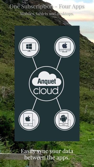
Four Platforms at no extra cost
• OMN apps are available on four platforms, including iOS, iPadOS and macOS.
• Sync your routes and maps between all of the apps with ease via Anquet Cloud.
• Purchase a subscription and use the maps on all four apps.
iOS App
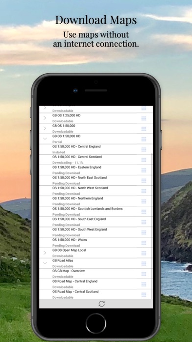
• Download OS maps to store on your phone/tablet to use them offline without an internet connection.
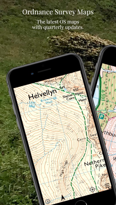
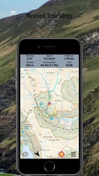
• See your position in real-time on the latest Ordnance Survey maps.
• Record tracklogs of where you have been.
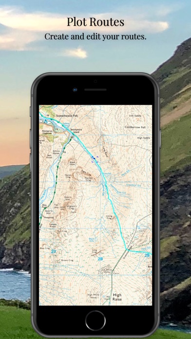
• Plot routes, edit and style them.
• Fully featured offline search, including place names and postcodes.
• Use Ordnance Survey grid references, latitude/longitude, or UTM.
Maps
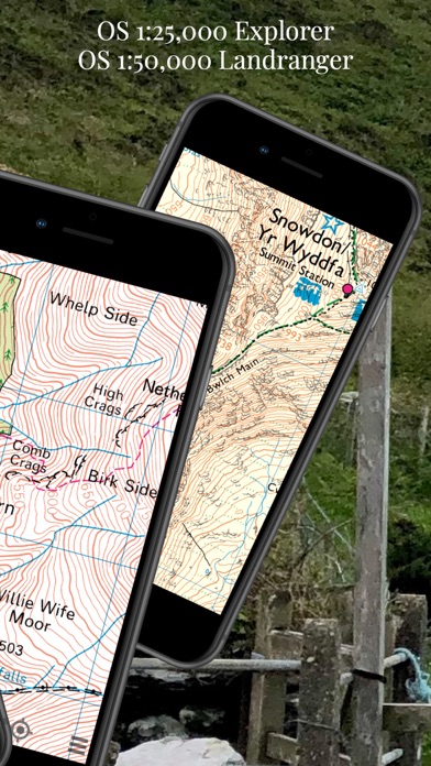
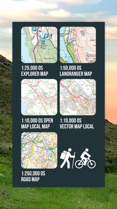
• Access the latest Ordnance Survey 1:25,000 scale Explorer maps and 1:50,000 scale Landranger maps.
• High Definition and Standard Definition Ordnance Survey maps are available.
• Superfast map rendering to any zoom level.
• Use your maps on four platforms, including macOS and iOS via OMN apps on these platforms – no need to use a clunky web browser-based system.
• The option to stream maps when you have an internet connection.
Routes and Tracklogs
• Add and save waypoints.
• Plot, edit, and style your routes.
• Create your styles for routes and tracks with transparency, thickness, and colour.
• Choose from over 200 icons for waypoints, or import your own on OMN on your desktop.
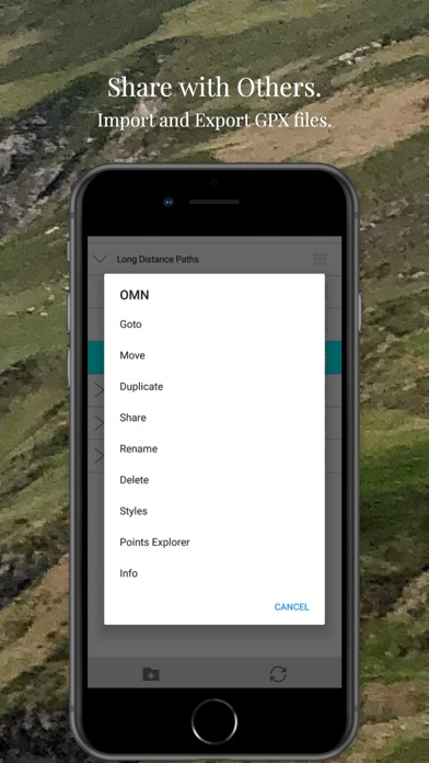
• Save routes and tracks and sync them to Anquet Cloud to access them on other OMN apps.
• Import and Export data in the industry-standard GPX file format.
Use maps, routes, and tracks within any of the four OMN apps. Therefore, you can plan a route on the larger screen on your home computer and quickly sync your route data to your iPhone or iPad. If you need to make a change whilst on the go, OMN iOS has a full route editing system. When you have completed your trip, review your tracklog either on OMN your mobile device or quickly sync to your desktop computer to view on a larger screen.
Anquet Maps have been building digital mapping systems since 2001. This latest version of OMN was built with the help of our customers, concentrating on usability and consistency across our apps on all platforms to allow users to learn the system once and easily move between computers without having to relearn everything. Although you have a full route editing system on your phone or tablet, having access to the same tools on your desktop computer will make your route planning much easier due to the larger screen.
OMN on the desktop also contains a very powerful print engine to allow you to make map prints to carry as a backup.
This app is subject to Apples Terms of Use (EULA) which can be read on the following link: https://www.apple.com/legal/internet-services/itunes/dev/stdeula/
Offline OS maps of Great Britain along with GPS functionality. Outdoor Map Navigator apps are available on four platforms, including iOS and macOS, allowing you to use the OS maps you subscribe to along with your routes on multiple phones, tablets, and computers.
Four Platforms at no extra cost
• OMN apps are available on four platforms, including iOS, iPadOS and macOS.
• Sync your routes and maps between all of the apps with ease via Anquet Cloud.
• Purchase a subscription and use the maps on all four apps.
iOS App
• Download OS maps to store on your phone/tablet to use them offline without an internet connection.
• See your position in real-time on the latest Ordnance Survey maps.
• Record tracklogs of where you have been.
• Plot routes, edit and style them.
• Fully featured offline search, including place names and postcodes.
• Use Ordnance Survey grid references, latitude/longitude, or UTM.
Maps
• Access the latest Ordnance Survey 1:25,000 scale Explorer maps and 1:50,000 scale Landranger maps.
• High Definition and Standard Definition Ordnance Survey maps are available.
• Superfast map rendering to any zoom level.
• Use your maps on four platforms, including macOS and iOS via OMN apps on these platforms – no need to use a clunky web browser-based system.
• The option to stream maps when you have an internet connection.
Routes and Tracklogs
• Add and save waypoints.
• Plot, edit, and style your routes.
• Create your styles for routes and tracks with transparency, thickness, and colour.
• Choose from over 200 icons for waypoints, or import your own on OMN on your desktop.
• Save routes and tracks and sync them to Anquet Cloud to access them on other OMN apps.
• Import and Export data in the industry-standard GPX file format.
Use maps, routes, and tracks within any of the four OMN apps. Therefore, you can plan a route on the larger screen on your home computer and quickly sync your route data to your iPhone or iPad. If you need to make a change whilst on the go, OMN iOS has a full route editing system. When you have completed your trip, review your tracklog either on OMN your mobile device or quickly sync to your desktop computer to view on a larger screen.
Anquet Maps have been building digital mapping systems since 2001. This latest version of OMN was built with the help of our customers, concentrating on usability and consistency across our apps on all platforms to allow users to learn the system once and easily move between computers without having to relearn everything. Although you have a full route editing system on your phone or tablet, having access to the same tools on your desktop computer will make your route planning much easier due to the larger screen.
OMN on the desktop also contains a very powerful print engine to allow you to make map prints to carry as a backup.
This app is subject to Apples Terms of Use (EULA) which can be read on the following link: https://www.apple.com/legal/internet-services/itunes/dev/stdeula/
OMN - Outdoor Map Navigator स्क्रीनशॉट


OMN - Outdoor Map Navigator जैसे ऐप्स
 OMN - Outdoor Map Navigator2.5
 OMN Junction-
 Radio Oman - Radio OMN(راديو عمان)-
 Map Map - Your Map on a Map5.0
 Outdoor Navigation ape@map-
 South Downs Outdoor Map Pro-
 Outdoor Explorer Utah - Map-
 North York Moors Outdoor Map-
 Pentlands Outdoor Map-
 Brecon Beacons Outdoor Map Pro-
 Exmoor Outdoor Map Pro-
 Brecon Beacons Outdoor Map-
OMN - Outdoor Map Navigator FAQ
मैं PGYER IPA HUB से OMN - Outdoor Map Navigator कैसे डाउनलोड करूं?
PGYER IPA HUB पर OMN - Outdoor Map Navigator मुफ्त डाउनलोड करने के लिए है?
PGYER IPA HUB से OMN - Outdoor Map Navigator डाउनलोड करने के लिए मुझे एक खाता चाहिए?
मैं PGYER IPA HUB पर OMN - Outdoor Map Navigator के साथ समस्या कैसे रिपोर्ट कर सकता हूँ?
क्या आपको यह मददगार पाया
हाँ
नहीं
सबसे लोकप्रिय
Sing It - Ear TrainerA must app for every musician, singer, or just for fun.
Test,train, and improve your musical ear an
Tube PiP - PiP for YouTubeTube PiP - the ultimate YouTube companion for iOS:
1. Picture in Picture (PiP) Playback: Watch YouT
Papaya Ouch!In the game Papaya Ouch!, you can experience backpack management, tower defense, TD, merge, match 2,
Lets Go VPNLets Go VPN, the most advanced VPN, is designed by a team of top developers who strive to ensure all
Paprika Recipe Manager 3Organize your recipes. Create grocery lists. Plan your meals. Download recipes from your favorite we
War Pigeons UnboundedWar is coming. Deep down in top secret military labs they have evolved, mutated - and escaped. The f
Procreate PocketApp of the Year winner Procreate Pocket is the most feature-packed and versatile art app ever design
Cowboy Westland survival runAre you ready to take part in the #1 exciting 3D western adventure? Cowboy Westland survival run mak
Max: Stream HBO, TV, & MoviesIt’s all here. Iconic series, award-winning movies, fresh originals, and family favorites, featuring
TonalEnergy Tuner & MetronomeFor musicians from pros to beginners, whether you sing, play a brass, woodwind or stringed instrumen
SkyView®SkyView® brings stargazing to everyone. Simply point your iPhone, iPad, or iPod at the sky to identi
Ninja Dash 2015Ninja Dash 2015 is the fast paced running game!<br>On these maze fields, rush to the end of this nin
Tami-Live Chat&VideoTami is an app that records daily life and ideas.<br><br>You can use it to record your every day, wh
SALE Camera - marketing camera effects plus photo editorSALE Camera Help you create the best Business to consumer Stock Photos and Images. provides 300 filt
DevTutor for SwiftUI"DevTutor" is an application designed to assist developers in creating exceptional apps using SwiftU
Mokens League SoccerDive into Mokens League Soccer and experience the new era of soccer gaming!
Esports for Everyone: W
Zombie ZZOMBIE ENDLESS RUNNER LIKES NO OTHER!<br><br>WHY?<br><br>* Awesome graphic quality!<br><br>* Simplif
Dead Z - Zombie SurvivalCatastrophic explosion at the Omega Labs started the apocalypse, now spreading across the Earth.
Ta
HotSchedulesHotSchedules is the industry's leading employee scheduling app because it’s the fastest and easiest
ChatGPTIntroducing ChatGPT for iOS: OpenAI’s latest advancements at your fingertips.
This official app is
Disney StoreDisney Store is your official home for exclusive collections, designer collaborations, and one-of-a-
fight back tennisa Pong game with Tennis style, the gameplay itself is very simple, you can using Touch. Ball speed w
Dr. Mina AdlyMina Adly mobile app provides students with portable instant access to a selection of services.
Usi
iVerify BasiciVerify Basic is your gateway to enhanced device security and threat awareness, offering a glimpse i