Boating Adriatic Sea South East GPS Map Navigator
5Valutazione
Sep 4, 2017Ultimo aggiornamento
5.5Versione
Come installare il file .IPA
Condividi
Informazioni su Boating Adriatic Sea South East GPS Map Navigator
!! TRY before BUY !!!
Try now the new FlyToMap web viewer to see all available maps worldwide !!! Visit viewer.flytomap.com
■ “Download any FlytoMap application for Free! By purchasing FlytoMap All-in-One App.”
■ !! Watch "FlyToMap GPS" app video on www.appreview.com and www.youtube.com !!
► New Design - Exclusively for the iPhone: FlyToMap multi-dimensional charts OVERLAYED with Satellite photos and map features.
► The unique application on App Store with this cutting edge technology.
► New iPhone 3GS Magnetic Compass integration.
- PARK MAPS:
Park maps are extremely advanced embedded electronic charts with all information collected from the National/State Park and Forest Services and many other local sources. The maps contain all trails (Hiking, Biking, Equestrian trails etc.,) and Points of interests (POI) like Campgrounds, Visitor Centers, Lookout points, Eating places, Ranger Stations, Picnic areas, Boat/Canoe ramps, Parking areas etc. and much more:
“all Trails, Lakes and Rivers within the Parks”
“Park boundary”
“Elevation Contours with 10 meters step” (only "Topo" version)
“Mountain Peaks”
“All Roads and Railways”
...and full Travel Guide with photos, maps, history, not to miss places.....
--------------------------------------------------------------------------------------------------------------------------
How to use:
“Zoom and Pan fast just by a finger touch”
“Use Latitudes and Longitudes to go to your favorite places”
"Record your GPS Track"
“Detailed touristic guide at your finger's disposal”
“Navigate and see your GPS position on the map”
“Geo-Tagged photo management”
“Insert the target/destination ‘Waypoint’ and see in real time your speed, distance and direction to destination”
“Insert Unlimited Markers near favorite places on the map”
“Search your Favorite points or any location by name”
“Set On/Off Elevation Contours if you feel data is cluttering”
- WATER MAPS (Marine):
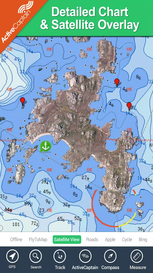
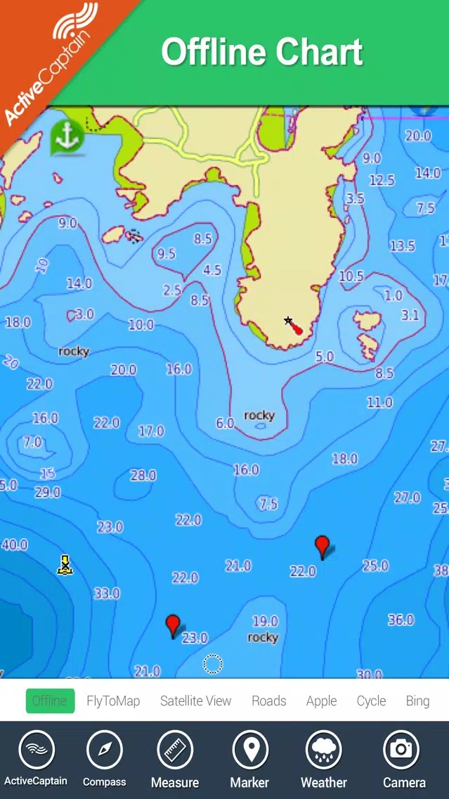
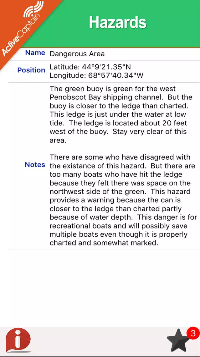
The new ‘iPhone Marine Navigator’: it contains embedded Electronic Nautical Charts (ENC) from NOAA and Corps of Engineers compressed to store the largest coverage. You can transform your iPhone in a chart plotter with best NOAA-USACE, ENC S57 cartography; which includes Coastline, Anchoring areas, Fishing areas, Restriction areas, Obstructions, Rocks, Buoys, Beacons, Lights, Depth contours (with values displayed in real time on map), Spot Soundings and more. Every effort is made to be as accurate as possible when presenting information for every sea area.
- LAKE MAPS:
High quality lake maps with detailed information and important features compressed to assure the larger coverage. Lake maps contain the most important lakes with detailed Depth Contours, Boat Ramps, Fishing spots etc. Maps also include Trails, Roads and Railways information.
- TRAVEL MAPS:
These Maps cover most interesting touristic areas combining Sea and Land information to allow you a complete travel experience. These are the best Maps to travel on fascinating voyages; map focus on the best Beach spots along the Coastline, Major ports, Sailing, Fishing, Picnic areas, Parks, Hiking, Biking, Clubs, Restaurants, Famous Hotels, Museums, Shopping areas, and much more.
A Travel Guide with photos, maps, history, not to miss places..... is included.
- HUNT MAPS:
These maps are designed specifically for hunting activities.
They contain the best hunting maps of the area with all the information for a safety and unforgettable hunting experience.
These maps are including all Parks, Forests, Trails, Huts, WMA (Wildlife Management Areas), Refuges, Point of Interests, etc. and a complete topographic map (Elevation contours, lakes, rivers, streams, roads, etc.).
A complete Hunting Guide with information about Season, Limits, Licensing, restrictions, etc.......is included.
Note:
"Continued use of GPS running in the background can dramatically decrease battery life."
"Turn off GPS when not in use"
Try now the new FlyToMap web viewer to see all available maps worldwide !!! Visit viewer.flytomap.com
■ “Download any FlytoMap application for Free! By purchasing FlytoMap All-in-One App.”
■ !! Watch "FlyToMap GPS" app video on www.appreview.com and www.youtube.com !!
► New Design - Exclusively for the iPhone: FlyToMap multi-dimensional charts OVERLAYED with Satellite photos and map features.
► The unique application on App Store with this cutting edge technology.
► New iPhone 3GS Magnetic Compass integration.
- PARK MAPS:
Park maps are extremely advanced embedded electronic charts with all information collected from the National/State Park and Forest Services and many other local sources. The maps contain all trails (Hiking, Biking, Equestrian trails etc.,) and Points of interests (POI) like Campgrounds, Visitor Centers, Lookout points, Eating places, Ranger Stations, Picnic areas, Boat/Canoe ramps, Parking areas etc. and much more:
“all Trails, Lakes and Rivers within the Parks”
“Park boundary”
“Elevation Contours with 10 meters step” (only "Topo" version)
“Mountain Peaks”
“All Roads and Railways”
...and full Travel Guide with photos, maps, history, not to miss places.....
--------------------------------------------------------------------------------------------------------------------------
How to use:
“Zoom and Pan fast just by a finger touch”
“Use Latitudes and Longitudes to go to your favorite places”
"Record your GPS Track"
“Detailed touristic guide at your finger's disposal”
“Navigate and see your GPS position on the map”
“Geo-Tagged photo management”
“Insert the target/destination ‘Waypoint’ and see in real time your speed, distance and direction to destination”
“Insert Unlimited Markers near favorite places on the map”
“Search your Favorite points or any location by name”
“Set On/Off Elevation Contours if you feel data is cluttering”
- WATER MAPS (Marine):
The new ‘iPhone Marine Navigator’: it contains embedded Electronic Nautical Charts (ENC) from NOAA and Corps of Engineers compressed to store the largest coverage. You can transform your iPhone in a chart plotter with best NOAA-USACE, ENC S57 cartography; which includes Coastline, Anchoring areas, Fishing areas, Restriction areas, Obstructions, Rocks, Buoys, Beacons, Lights, Depth contours (with values displayed in real time on map), Spot Soundings and more. Every effort is made to be as accurate as possible when presenting information for every sea area.
- LAKE MAPS:
High quality lake maps with detailed information and important features compressed to assure the larger coverage. Lake maps contain the most important lakes with detailed Depth Contours, Boat Ramps, Fishing spots etc. Maps also include Trails, Roads and Railways information.
- TRAVEL MAPS:
These Maps cover most interesting touristic areas combining Sea and Land information to allow you a complete travel experience. These are the best Maps to travel on fascinating voyages; map focus on the best Beach spots along the Coastline, Major ports, Sailing, Fishing, Picnic areas, Parks, Hiking, Biking, Clubs, Restaurants, Famous Hotels, Museums, Shopping areas, and much more.
A Travel Guide with photos, maps, history, not to miss places..... is included.
- HUNT MAPS:
These maps are designed specifically for hunting activities.
They contain the best hunting maps of the area with all the information for a safety and unforgettable hunting experience.
These maps are including all Parks, Forests, Trails, Huts, WMA (Wildlife Management Areas), Refuges, Point of Interests, etc. and a complete topographic map (Elevation contours, lakes, rivers, streams, roads, etc.).
A complete Hunting Guide with information about Season, Limits, Licensing, restrictions, etc.......is included.
Note:
"Continued use of GPS running in the background can dramatically decrease battery life."
"Turn off GPS when not in use"
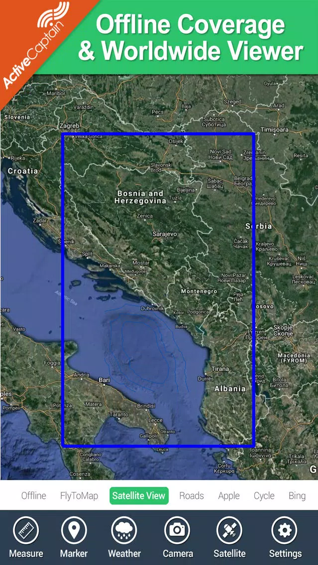
Screenshot di Boating Adriatic Sea South East GPS Map Navigator


App Simili a Boating Adriatic Sea South East GPS Map Navigator
 Boating Adriatic Sea South East GPS Map Navigator-
 NaviApp Adriatic - best navigation of the Croatia Adriatic Sea-
 Mediterranean South East - GPS Map Navigator-
 Marine: Aegean Sea (South) HD - GPS Map Navigator-
 Marine: Aegean Sea (South) - GPS Map Navigator-
 Marine : London - Thames boating GPS map Navigator-
 Marine : East England HD GPS Map navigator-
 Marine: Germany East - GPS Map Navigator-
 Marine: Germany East HD - GPS Map Navigator-
 Aegean Sea South Boating Chart-
 Marine : Alaska South West HD - GPS Map Navigator-
 Marine: South Africa HD - GPS Map Navigator-
App di Flytomap
 Real Tides & Currents Graph HD4.7
 UK Ireland Nautical Charts HD4.0
 AIS Maps: Marine & Lake charts3.7
 Flytomap All in One HD Charts3.3
 Wind forecast for Windgurus2.4
 Florida Nautical Charts GPS HD2.2
 Lake Murray SC Fishing Maps HD2.1
 Great Lakes HD Nautical Charts2.1
 Maldives GPS Map Navigator1.9
 NOAA Buoys - Charts & Weather1.6
 Maine Lakes - GPS fishing maps1.3
 Iowa lakes - charts offline1.0
Boating Adriatic Sea South East GPS Map Navigator FAQ
Come faccio a scaricare Boating Adriatic Sea South East GPS Map Navigator da PGYER IPA HUB?
Il Boating Adriatic Sea South East GPS Map Navigator su PGYER IPA HUB è gratuito?
Ho bisogno di un account per scaricare Boating Adriatic Sea South East GPS Map Navigator da PGYER IPA HUB?
Come posso segnalare un problema con Boating Adriatic Sea South East GPS Map Navigator su PGYER IPA HUB?
Hai trovato utile questo suggerimento?
Sì
No
Più popolare
Sing It - Ear TrainerA must app for every musician, singer, or just for fun.
Test,train, and improve your musical ear an
Tube PiP - PiP for YouTubeTube PiP - the ultimate YouTube companion for iOS:
1. Picture in Picture (PiP) Playback: Watch YouT
Papaya Ouch!In the game Papaya Ouch!, you can experience backpack management, tower defense, TD, merge, match 2,
Lets Go VPNLets Go VPN, the most advanced VPN, is designed by a team of top developers who strive to ensure all
Paprika Recipe Manager 3Organize your recipes. Create grocery lists. Plan your meals. Download recipes from your favorite we
War Pigeons UnboundedWar is coming. Deep down in top secret military labs they have evolved, mutated - and escaped. The f
Procreate PocketApp of the Year winner Procreate Pocket is the most feature-packed and versatile art app ever design
Cowboy Westland survival runAre you ready to take part in the #1 exciting 3D western adventure? Cowboy Westland survival run mak
Max: Stream HBO, TV, & MoviesIt’s all here. Iconic series, award-winning movies, fresh originals, and family favorites, featuring
TonalEnergy Tuner & MetronomeFor musicians from pros to beginners, whether you sing, play a brass, woodwind or stringed instrumen
SkyView®SkyView® brings stargazing to everyone. Simply point your iPhone, iPad, or iPod at the sky to identi
Ninja Dash 2015Ninja Dash 2015 is the fast paced running game!<br>On these maze fields, rush to the end of this nin
Tami-Live Chat&VideoTami is an app that records daily life and ideas.<br><br>You can use it to record your every day, wh
SALE Camera - marketing camera effects plus photo editorSALE Camera Help you create the best Business to consumer Stock Photos and Images. provides 300 filt
DevTutor for SwiftUI"DevTutor" is an application designed to assist developers in creating exceptional apps using SwiftU
Mokens League SoccerDive into Mokens League Soccer and experience the new era of soccer gaming!
Esports for Everyone: W
Zombie ZZOMBIE ENDLESS RUNNER LIKES NO OTHER!<br><br>WHY?<br><br>* Awesome graphic quality!<br><br>* Simplif
Dead Z - Zombie SurvivalCatastrophic explosion at the Omega Labs started the apocalypse, now spreading across the Earth.
Ta
HotSchedulesHotSchedules is the industry's leading employee scheduling app because it’s the fastest and easiest
ChatGPTIntroducing ChatGPT for iOS: OpenAI’s latest advancements at your fingertips.
This official app is
Disney StoreDisney Store is your official home for exclusive collections, designer collaborations, and one-of-a-
fight back tennisa Pong game with Tennis style, the gameplay itself is very simple, you can using Touch. Ball speed w
Dr. Mina AdlyMina Adly mobile app provides students with portable instant access to a selection of services.
Usi
iVerify BasiciVerify Basic is your gateway to enhanced device security and threat awareness, offering a glimpse i