Navstar - GPS & Map for Hikers
5评分
Sep 16, 2019最近更新
0.6.2版本
关于Navstar - GPS & Map for Hikers
Navstar process and segment the raw data your device (GPS receiver) is getting from the satellite network. This data complements many of the features that Navstar offer, the following:
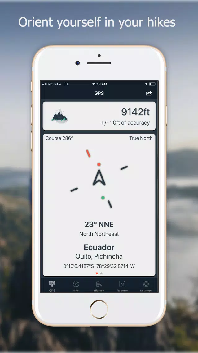
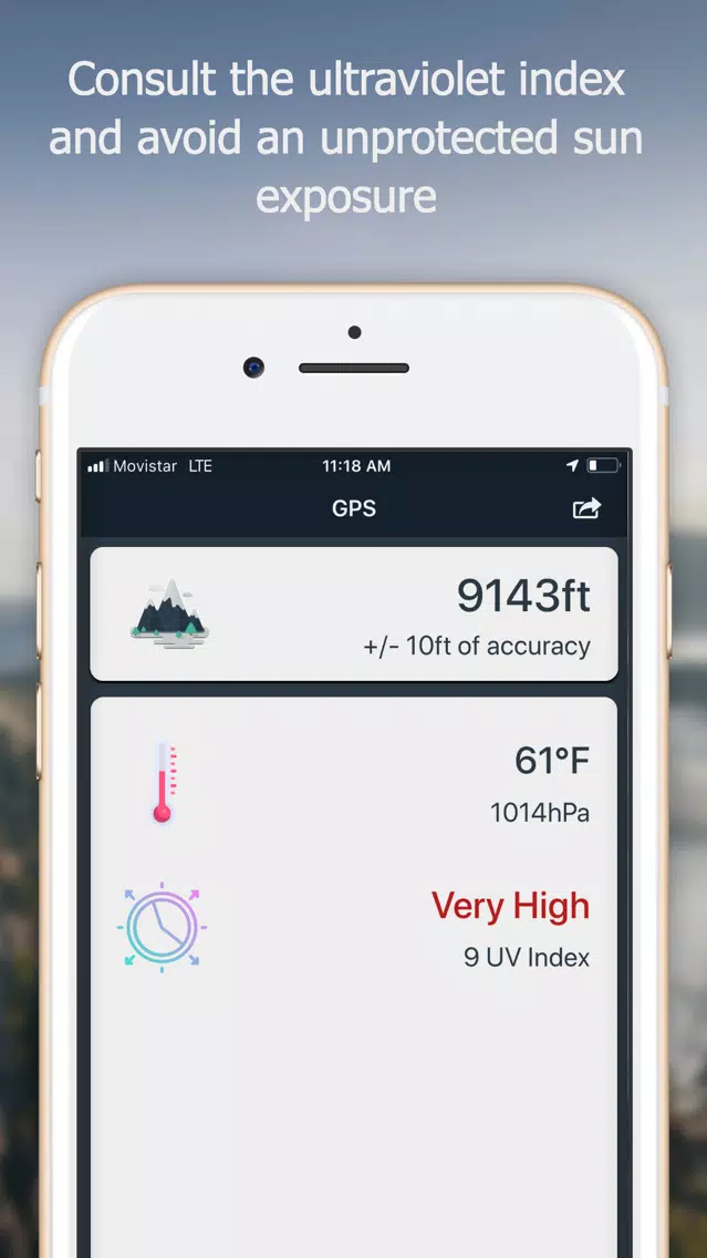
Inside the GPS tab
- Altitude from sea level, with the correction of the device barometer.
- Temperature and atmospheric pressure. (Touching the icon updates the value)
- UV (Ultraviolet) Index shows you the risk of harm from unprotected sun exposure. (Touching the icon updates the value)
- Compass with 32 points of references.
- Visual guidance (a cute little ball) that moves around the compass and always points to the geographical coordinates where the hike started.
- Geolocation: country, city, and province.
- Coordinates in different formats.
- You can take a screenshot of your current altitude and location.
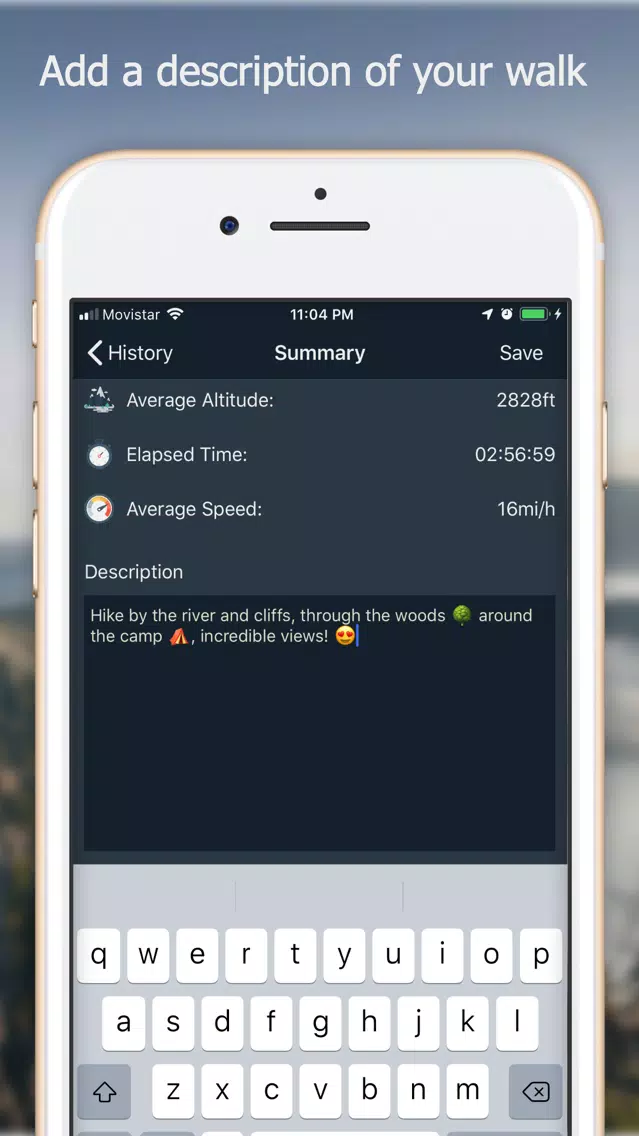
Inside the Hike tab
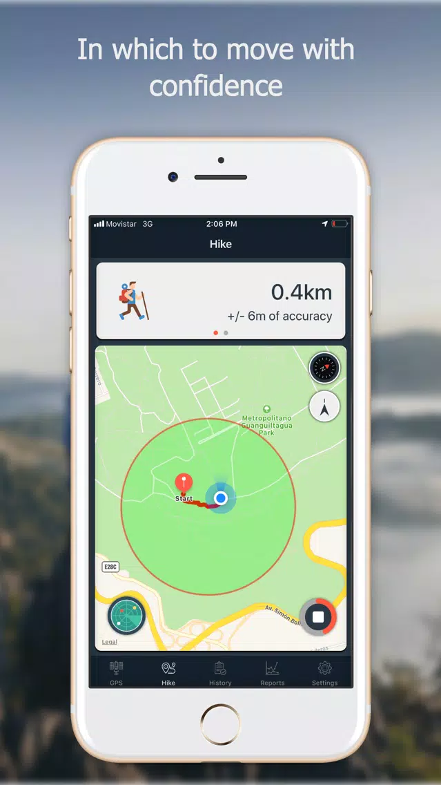
- Track your hike in the map.
- The distance traveled is updated in real-time.
- The elapsed time.
- The current speed.
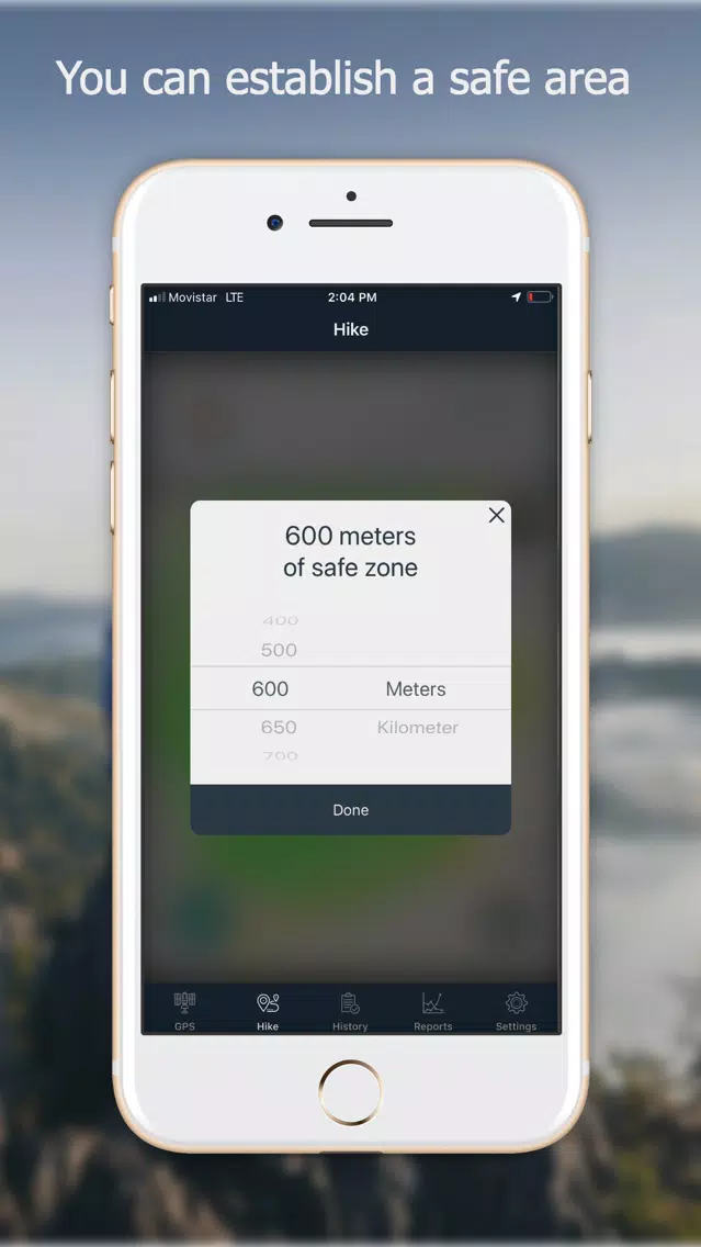
- You can delimiter your hike inside a circular safe zone, and the app warns you when you enter or exit this zone.
- Touching a map annotation shows the coordinates for that location with the option to share it with apps like Waze, Google Map, or just plain text.
- When the hike is over the app shows you a summary of your walk, where you can add a description and choose to save it or not.
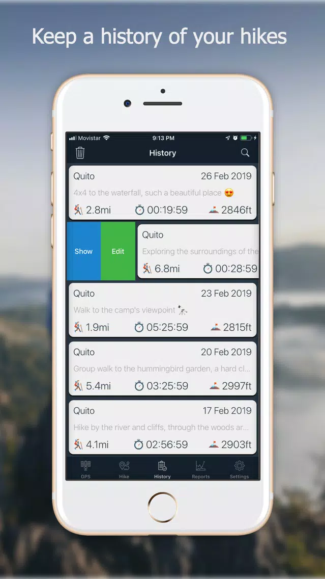
Inside the History tab
- List of all your saved hikes.
- You can delete a hike.
- You can edit a hike and change the associated description.
- You can load a hike and visualize it in the map (at the Hike tab) including the distance traveled and rest of information.
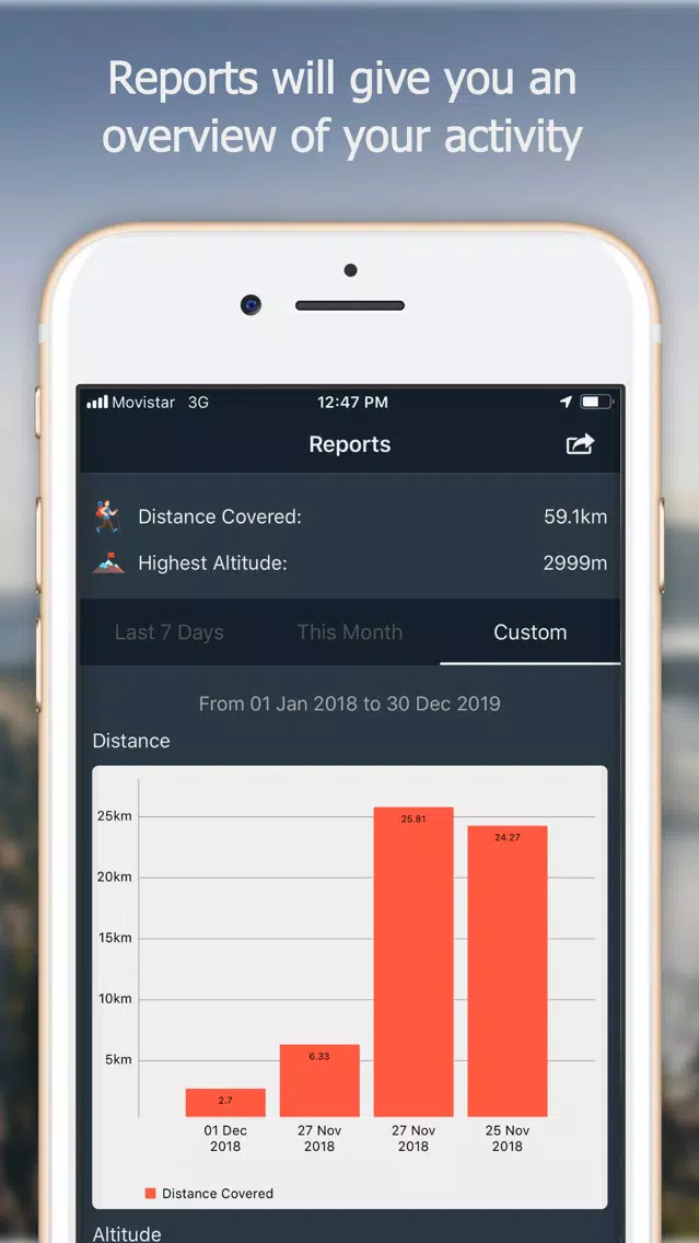
Inside the Reports tab
- A summary of the distance and top altitude you have covered and reach during your saved hikes.
- A graphical comparison between all your saved walks, segmented in the last seven days, the current month and a custom date range you can choose.
- You can also take a screenshot of these reports in a simple way.
Inside the Settings tab
- You can customize units and formats.
- You can customize the magnetic declination.
- You can customize the type of the map from Standard, Satellite, or Hybrid.
- You can enable or disable the visual guidance on the GPS tab.
- You can choose from two of the available algorithms used to measure the distance covered during your hikes.
- You can prevent the screen from auto-lock when using Navstar.
- The “About” section where you can know a litter more about me and contact me if you wish.
That’s all for now, folks. I want you to know that your feedback is essential to us. You can send your comments and suggestions through the “About” section inside Navstar, and also to:
navstar [at] swiftbycoding [dot] dev
or
@NavstarApp at Twitter
If you are enjoying the app, please leave us a rating and a review here at the App Store. Thank you!
Inside the GPS tab
- Altitude from sea level, with the correction of the device barometer.
- Temperature and atmospheric pressure. (Touching the icon updates the value)
- UV (Ultraviolet) Index shows you the risk of harm from unprotected sun exposure. (Touching the icon updates the value)
- Compass with 32 points of references.
- Visual guidance (a cute little ball) that moves around the compass and always points to the geographical coordinates where the hike started.
- Geolocation: country, city, and province.
- Coordinates in different formats.
- You can take a screenshot of your current altitude and location.
Inside the Hike tab
- Track your hike in the map.
- The distance traveled is updated in real-time.
- The elapsed time.
- The current speed.
- You can delimiter your hike inside a circular safe zone, and the app warns you when you enter or exit this zone.
- Touching a map annotation shows the coordinates for that location with the option to share it with apps like Waze, Google Map, or just plain text.
- When the hike is over the app shows you a summary of your walk, where you can add a description and choose to save it or not.
Inside the History tab
- List of all your saved hikes.
- You can delete a hike.
- You can edit a hike and change the associated description.
- You can load a hike and visualize it in the map (at the Hike tab) including the distance traveled and rest of information.
Inside the Reports tab
- A summary of the distance and top altitude you have covered and reach during your saved hikes.
- A graphical comparison between all your saved walks, segmented in the last seven days, the current month and a custom date range you can choose.
- You can also take a screenshot of these reports in a simple way.
Inside the Settings tab
- You can customize units and formats.
- You can customize the magnetic declination.
- You can customize the type of the map from Standard, Satellite, or Hybrid.
- You can enable or disable the visual guidance on the GPS tab.
- You can choose from two of the available algorithms used to measure the distance covered during your hikes.
- You can prevent the screen from auto-lock when using Navstar.
- The “About” section where you can know a litter more about me and contact me if you wish.
That’s all for now, folks. I want you to know that your feedback is essential to us. You can send your comments and suggestions through the “About” section inside Navstar, and also to:
navstar [at] swiftbycoding [dot] dev
or
@NavstarApp at Twitter
If you are enjoying the app, please leave us a rating and a review here at the App Store. Thank you!
Navstar - GPS & Map for Hikers应用截图


类似Navstar - GPS & Map for Hikers的应用
 Navstar - GPS & Map for Hikers-
 Gissa Trafikskylten - Perfekt för dig som pluggar för att ta körkor ( bil, moped och motorcykel körkor )-
 NAVSTAR GPS-
 Navstar Tracking-
 Hikers-
 Social Hikers4.7
 Hikers Assistant Plus-
 Sacramento Bike Hikers5.0
 Hikers Hub-
 Hudson Valley Hikers App-
 Hikers Trail-
 weHike for hikers-
最受欢迎
Sing It - Ear TrainerA must app for every musician, singer, or just for fun.
Test,train, and improve your musical ear an
Tube PiP - PiP for YouTubeTube PiP - the ultimate YouTube companion for iOS:
1. Picture in Picture (PiP) Playback: Watch YouT
Papaya Ouch!In the game Papaya Ouch!, you can experience backpack management, tower defense, TD, merge, match 2,
Lets Go VPNLets Go VPN, the most advanced VPN, is designed by a team of top developers who strive to ensure all
Paprika Recipe Manager 3Organize your recipes. Create grocery lists. Plan your meals. Download recipes from your favorite we
War Pigeons UnboundedWar is coming. Deep down in top secret military labs they have evolved, mutated - and escaped. The f
Procreate PocketApp of the Year winner Procreate Pocket is the most feature-packed and versatile art app ever design
Cowboy Westland survival runAre you ready to take part in the #1 exciting 3D western adventure? Cowboy Westland survival run mak
Max: Stream HBO, TV, & MoviesIt’s all here. Iconic series, award-winning movies, fresh originals, and family favorites, featuring
TonalEnergy Tuner & MetronomeFor musicians from pros to beginners, whether you sing, play a brass, woodwind or stringed instrumen
SkyView®SkyView® brings stargazing to everyone. Simply point your iPhone, iPad, or iPod at the sky to identi
Ninja Dash 2015Ninja Dash 2015 is the fast paced running game!<br>On these maze fields, rush to the end of this nin
Tami-Live Chat&VideoTami is an app that records daily life and ideas.<br><br>You can use it to record your every day, wh
SALE Camera - marketing camera effects plus photo editorSALE Camera Help you create the best Business to consumer Stock Photos and Images. provides 300 filt
DevTutor for SwiftUI"DevTutor" is an application designed to assist developers in creating exceptional apps using SwiftU
Mokens League SoccerDive into Mokens League Soccer and experience the new era of soccer gaming!
Esports for Everyone: W
Zombie ZZOMBIE ENDLESS RUNNER LIKES NO OTHER!<br><br>WHY?<br><br>* Awesome graphic quality!<br><br>* Simplif
Dead Z - Zombie SurvivalCatastrophic explosion at the Omega Labs started the apocalypse, now spreading across the Earth.
Ta
HotSchedulesHotSchedules is the industry's leading employee scheduling app because it’s the fastest and easiest
ChatGPTIntroducing ChatGPT for iOS: OpenAI’s latest advancements at your fingertips.
This official app is
Disney StoreDisney Store is your official home for exclusive collections, designer collaborations, and one-of-a-
fight back tennisa Pong game with Tennis style, the gameplay itself is very simple, you can using Touch. Ball speed w
Dr. Mina AdlyMina Adly mobile app provides students with portable instant access to a selection of services.
Usi
iVerify BasiciVerify Basic is your gateway to enhanced device security and threat awareness, offering a glimpse i