UpGo!
5Рейтинг
Sep 15, 2024Последнее обновление
5.9.0Версия
Как установить файл .IPA
Поделиться
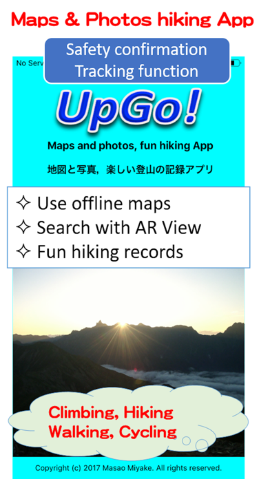
О UpGo!
Climbing safely with abundant functions such as browsing the map offline, notifying the current position by voice, searching for a destination with AR View, importing an external GPX file, and safety confirmation.
UpGo!'s recorded data is stored only on your device and can be used safely without advertisements. You can save up to 5 times in the free version. If you like it, you can save it as many times as you like (only billing 120 yen), and you can use the tracking function using iCloud. With the tracking function, the movement data of the person who is acting on another iPhone or iPad is displayed on the UpGo! map in near real time. This is an epoch-making function for confirming safety.
<Major features>
◎ Use offline maps
If you browse the map in advance, you can see the map even in places where there is no internet connection. There is no charge no matter how you look.
◎ Map selection
You can select from four types of maps: Japan maps(Geospatial Information Authority of Japan), Apple Standard maps, Aerial photographs, Aerial photographs + Standard maps.
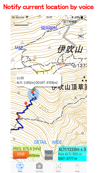
◎ Voice notification
You can hear the time, altitude, and travel distance by voice at set time interval.
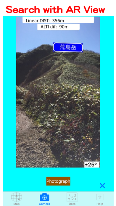
◎ AR View using AR technology
AR View that displays the destination label on the camera image has been realized. The position of the goal can be confirmed with an image, and the altitude difference from the destination (in Japan) and the straight line distance are displayed.
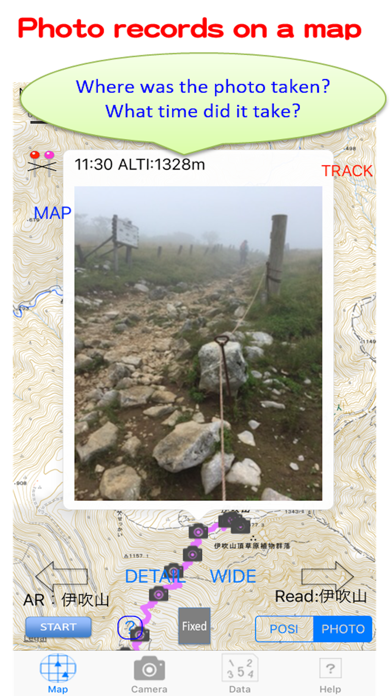
◎ Map and photo album
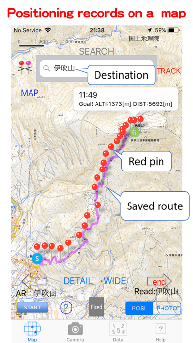
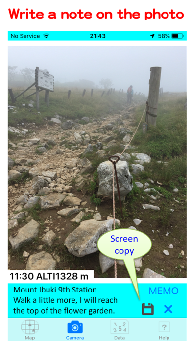
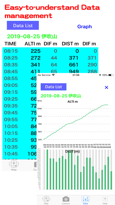
You can look back at the Positioning Record and Photo Record with the map and look back on the activities later.
◎ Safety confirmation with tracking function
Using iCloud signed in with the same Apple ID, you can display movement data on the UpGo! map on a different device from the person who is walking (being active). (Requires mobile signal)
◎ Activities that spread through information exchange.
You can send and receive UpGo! data to other UpGo!. In addition, the photo screen with the positioning results and action notes can be saved on the device. You can share real lively information with people who do not have UpGo!.
*GPX files provided by general mountain climbing or hiking sites can be read and walking courses can be displayed.
◎ Used for many purposes
In addition to climbing and hiking, it can also be used for cycling and walking.
*The first time you use UpGo!, Map of Tokyo will be displayed. Next, when you start positioning by tapping the 'START' button, you will be asked for permission to use location information. Please allow it to be used.
<Recommended models and OS>
The recommended model is iPhone5S or later, and the OS is iOS8 or later.
Important points
◎UpGo! is not suitable for mountaineering outside of Japan. Use in the city is recommended.
◎ UpGp! developer cannot be held responsible for accidents in UpGo! Activities. Please use it safely at your own risk.
◎ It is recommended that you carry a mobile battery, etc., in preparation for battery consumption.
◎ There are rules regarding the use of maps of the Geospatial Information Authority of Japan. Please note that you may need to apply for use when the map background image is uploaded to the Internet or distributed in print.
◎ The mechanism to obtain the elevation data by dropping the purple pin uses the elevation API of the Geospatial Information Authority of Japan. ’Src = 5m (レーザ)’ displayed in the balloon means 5mDEM obtained by aerial laser surveying. ’Src = 5m (写真測量)’ means 5mDEM obtained from photographic data, and ’Src = 10m’ means 10mDEM obtained from contour lines. Geospatial Information Authority's elevation API is open to the public and may be discontinued without prior notice.
UpGo!'s recorded data is stored only on your device and can be used safely without advertisements. You can save up to 5 times in the free version. If you like it, you can save it as many times as you like (only billing 120 yen), and you can use the tracking function using iCloud. With the tracking function, the movement data of the person who is acting on another iPhone or iPad is displayed on the UpGo! map in near real time. This is an epoch-making function for confirming safety.
<Major features>
◎ Use offline maps
If you browse the map in advance, you can see the map even in places where there is no internet connection. There is no charge no matter how you look.
◎ Map selection
You can select from four types of maps: Japan maps(Geospatial Information Authority of Japan), Apple Standard maps, Aerial photographs, Aerial photographs + Standard maps.
◎ Voice notification
You can hear the time, altitude, and travel distance by voice at set time interval.
◎ AR View using AR technology
AR View that displays the destination label on the camera image has been realized. The position of the goal can be confirmed with an image, and the altitude difference from the destination (in Japan) and the straight line distance are displayed.
◎ Map and photo album
You can look back at the Positioning Record and Photo Record with the map and look back on the activities later.
◎ Safety confirmation with tracking function
Using iCloud signed in with the same Apple ID, you can display movement data on the UpGo! map on a different device from the person who is walking (being active). (Requires mobile signal)
◎ Activities that spread through information exchange.
You can send and receive UpGo! data to other UpGo!. In addition, the photo screen with the positioning results and action notes can be saved on the device. You can share real lively information with people who do not have UpGo!.
*GPX files provided by general mountain climbing or hiking sites can be read and walking courses can be displayed.
◎ Used for many purposes
In addition to climbing and hiking, it can also be used for cycling and walking.
*The first time you use UpGo!, Map of Tokyo will be displayed. Next, when you start positioning by tapping the 'START' button, you will be asked for permission to use location information. Please allow it to be used.
<Recommended models and OS>
The recommended model is iPhone5S or later, and the OS is iOS8 or later.
Important points
◎UpGo! is not suitable for mountaineering outside of Japan. Use in the city is recommended.
◎ UpGp! developer cannot be held responsible for accidents in UpGo! Activities. Please use it safely at your own risk.
◎ It is recommended that you carry a mobile battery, etc., in preparation for battery consumption.
◎ There are rules regarding the use of maps of the Geospatial Information Authority of Japan. Please note that you may need to apply for use when the map background image is uploaded to the Internet or distributed in print.
◎ The mechanism to obtain the elevation data by dropping the purple pin uses the elevation API of the Geospatial Information Authority of Japan. ’Src = 5m (レーザ)’ displayed in the balloon means 5mDEM obtained by aerial laser surveying. ’Src = 5m (写真測量)’ means 5mDEM obtained from photographic data, and ’Src = 10m’ means 10mDEM obtained from contour lines. Geospatial Information Authority's elevation API is open to the public and may be discontinued without prior notice.
Скриншоты UpGo!


Самые популярные
Sing It - Ear TrainerA must app for every musician, singer, or just for fun.
Test,train, and improve your musical ear an
Tube PiP - PiP for YouTubeTube PiP - the ultimate YouTube companion for iOS:
1. Picture in Picture (PiP) Playback: Watch YouT
Papaya Ouch!In the game Papaya Ouch!, you can experience backpack management, tower defense, TD, merge, match 2,
Lets Go VPNLets Go VPN, the most advanced VPN, is designed by a team of top developers who strive to ensure all
Paprika Recipe Manager 3Organize your recipes. Create grocery lists. Plan your meals. Download recipes from your favorite we
War Pigeons UnboundedWar is coming. Deep down in top secret military labs they have evolved, mutated - and escaped. The f
Procreate PocketApp of the Year winner Procreate Pocket is the most feature-packed and versatile art app ever design
Cowboy Westland survival runAre you ready to take part in the #1 exciting 3D western adventure? Cowboy Westland survival run mak
Max: Stream HBO, TV, & MoviesIt’s all here. Iconic series, award-winning movies, fresh originals, and family favorites, featuring
TonalEnergy Tuner & MetronomeFor musicians from pros to beginners, whether you sing, play a brass, woodwind or stringed instrumen
SkyView®SkyView® brings stargazing to everyone. Simply point your iPhone, iPad, or iPod at the sky to identi
Ninja Dash 2015Ninja Dash 2015 is the fast paced running game!<br>On these maze fields, rush to the end of this nin
Tami-Live Chat&VideoTami is an app that records daily life and ideas.<br><br>You can use it to record your every day, wh
SALE Camera - marketing camera effects plus photo editorSALE Camera Help you create the best Business to consumer Stock Photos and Images. provides 300 filt
DevTutor for SwiftUI"DevTutor" is an application designed to assist developers in creating exceptional apps using SwiftU
Mokens League SoccerDive into Mokens League Soccer and experience the new era of soccer gaming!
Esports for Everyone: W
Zombie ZZOMBIE ENDLESS RUNNER LIKES NO OTHER!<br><br>WHY?<br><br>* Awesome graphic quality!<br><br>* Simplif
Dead Z - Zombie SurvivalCatastrophic explosion at the Omega Labs started the apocalypse, now spreading across the Earth.
Ta
HotSchedulesHotSchedules is the industry's leading employee scheduling app because it’s the fastest and easiest
ChatGPTIntroducing ChatGPT for iOS: OpenAI’s latest advancements at your fingertips.
This official app is
Disney StoreDisney Store is your official home for exclusive collections, designer collaborations, and one-of-a-
fight back tennisa Pong game with Tennis style, the gameplay itself is very simple, you can using Touch. Ball speed w
Dr. Mina AdlyMina Adly mobile app provides students with portable instant access to a selection of services.
Usi
iVerify BasiciVerify Basic is your gateway to enhanced device security and threat awareness, offering a glimpse i