Maps n Trax - Offline Maps, GPS Tracks & Waypoints
1.0คะแนน
Sep 28, 2024อัปเดตล่าสุด
6.2.16เวอร์ชัน
เกี่ยวกับ Maps n Trax - Offline Maps, GPS Tracks & Waypoints
MAPS n TRAX is a VERSATILE and HIGHLY CUSTOMIZABLE offline map viewer, GPS track recording and WAYPOINT detail recorder.
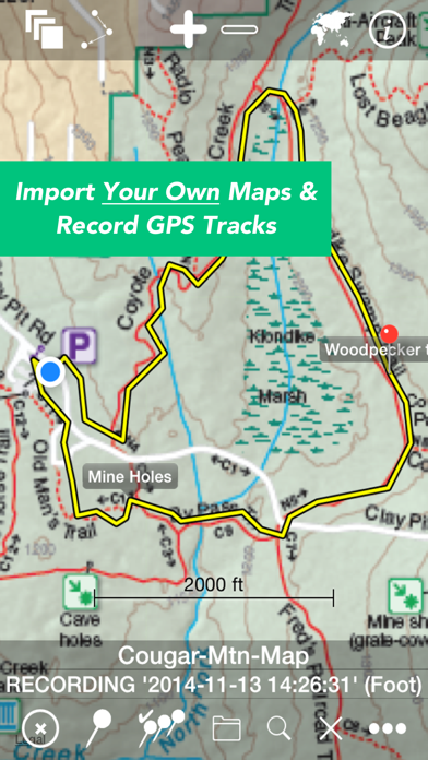
* IMPORT AND VIEW YOUR OWN MAPS and GPS tracks on your device, and record tracks and detailed WAYPOINT notes. MAPS n TRAX excels in rugged "off the grid" professional, academic, and recreational activity on land, sea or air!
* GREAT SUPPORT! MAPS n TRAX is well-supported with a detailed online User Guide (http://rallyto.com/maps-n-trax/maps-n-trax-user-guide/) and responsive, personal email support.
With MAPS n TRAX you can:
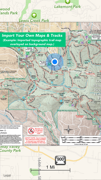
• Import and view your favorite maps (see supported file formats below*).
• View your current GPS location on your imported map.
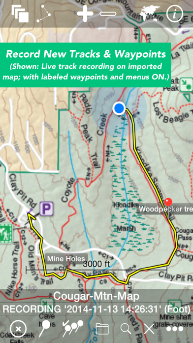
• Record GPS tracks.
• Record waypoint details including photographs and field notes.
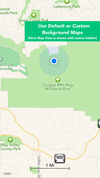
• View maps and tracks superimposed on familiar online background maps.
• Import GPS tracks from other sources or export your track records.
• Easily store, organize and access multiple maps and track files.
Use MAPS n TRAX to view specialized map files, topographic maps, or digital map image files and gps tracks on your iOS device. You can even import scanned paper maps or photos of maps!
Even when far beyond the reach of cellular data or WIFI networks, with MAPS n TRAX you can view your own downloaded maps and use the GPS navigational features of your iOS device.
MAPS n TRAX has numerous professional applications. Our customers use the app to support forest fire fighting operations; environmental and biological field research; search and rescue; petroleum and mining; real estate; geo-truthing; flying; sailing; and, academic research. The off-the-grid functionality and waypoint recording features provide a powerful mobile toolset.
MAPS n TRAX is also ideal for a wide range of outdoor recreational including: bushwalking, hiking, trekking, bird watching, treasure hunting, prospecting, camping, bicycle touring, hunting, fishing, snowmobiling, dogsledding, 4-wheel drive off-road motoring, geocaching, orienteering, randonneuring, mountain biking, skiing (downhill, backcountry, Nordic), and squatching, among others.
Many publicly available maps can be imported into MAPS n TRAX. In addition the app is well suited for applications that require specialist maps with details that are customized or are not widely available, such as highly detailed topographic maps obtained from your government mapping authority or specialized maps produced with GIS tools.
Details:
• Converts and displays a wide range of map and image file types including * PNG, JPEG, TIFF, GIFF, ESRI Shapefiles, ESRI File Geodatabase and Open Street Map (PBF & XML) and geo-referenced image formats such as GeoTIFF. (Note: .ozf2 & .ozfx3 files are NOT supported). See the User Guide for more information about working with these files.
• Imports and exports tracks in GPX and KML formats.
• Compatible with raster and vector map file types and projections used in commercial and open source Geographic Information Systems (GIS) software tools including ARCGIS and OpenStreetMaps.
• Automatically align geo-referenced image files or manually calibrate non-geo-referenced ones.
• Can display large maps and can join several consecutive large maps into a single huge map. The map size is limited only by the iPhone or iPad's storage capacity.
• Imported maps of different scales can be viewed simultaneously, adjacent to or overlapping each other.
• Multiple tracks can be displayed on maps simultaneously and tracks with named waypoints can be searched like a directory or gazetteer.
We recommend that you review our website www.rocketsplashgames.com/mapsntrax/support/ and the online User Guide to be sure that MAPS n TRAX suits your requirements. The User Guide section on Preparing Maps describes the process to prepare a plain image file for use as a location-calibrated and mobile-optimized map image.
Continued use of the GPS running in the background can dramatically reduce battery life on the iPhone or iPad.
* IMPORT AND VIEW YOUR OWN MAPS and GPS tracks on your device, and record tracks and detailed WAYPOINT notes. MAPS n TRAX excels in rugged "off the grid" professional, academic, and recreational activity on land, sea or air!
* GREAT SUPPORT! MAPS n TRAX is well-supported with a detailed online User Guide (http://rallyto.com/maps-n-trax/maps-n-trax-user-guide/) and responsive, personal email support.
With MAPS n TRAX you can:
• Import and view your favorite maps (see supported file formats below*).
• View your current GPS location on your imported map.
• Record GPS tracks.
• Record waypoint details including photographs and field notes.
• View maps and tracks superimposed on familiar online background maps.
• Import GPS tracks from other sources or export your track records.
• Easily store, organize and access multiple maps and track files.
Use MAPS n TRAX to view specialized map files, topographic maps, or digital map image files and gps tracks on your iOS device. You can even import scanned paper maps or photos of maps!
Even when far beyond the reach of cellular data or WIFI networks, with MAPS n TRAX you can view your own downloaded maps and use the GPS navigational features of your iOS device.
MAPS n TRAX has numerous professional applications. Our customers use the app to support forest fire fighting operations; environmental and biological field research; search and rescue; petroleum and mining; real estate; geo-truthing; flying; sailing; and, academic research. The off-the-grid functionality and waypoint recording features provide a powerful mobile toolset.
MAPS n TRAX is also ideal for a wide range of outdoor recreational including: bushwalking, hiking, trekking, bird watching, treasure hunting, prospecting, camping, bicycle touring, hunting, fishing, snowmobiling, dogsledding, 4-wheel drive off-road motoring, geocaching, orienteering, randonneuring, mountain biking, skiing (downhill, backcountry, Nordic), and squatching, among others.
Many publicly available maps can be imported into MAPS n TRAX. In addition the app is well suited for applications that require specialist maps with details that are customized or are not widely available, such as highly detailed topographic maps obtained from your government mapping authority or specialized maps produced with GIS tools.
Details:
• Converts and displays a wide range of map and image file types including * PNG, JPEG, TIFF, GIFF, ESRI Shapefiles, ESRI File Geodatabase and Open Street Map (PBF & XML) and geo-referenced image formats such as GeoTIFF. (Note: .ozf2 & .ozfx3 files are NOT supported). See the User Guide for more information about working with these files.
• Imports and exports tracks in GPX and KML formats.
• Compatible with raster and vector map file types and projections used in commercial and open source Geographic Information Systems (GIS) software tools including ARCGIS and OpenStreetMaps.
• Automatically align geo-referenced image files or manually calibrate non-geo-referenced ones.
• Can display large maps and can join several consecutive large maps into a single huge map. The map size is limited only by the iPhone or iPad's storage capacity.
• Imported maps of different scales can be viewed simultaneously, adjacent to or overlapping each other.
• Multiple tracks can be displayed on maps simultaneously and tracks with named waypoints can be searched like a directory or gazetteer.
We recommend that you review our website www.rocketsplashgames.com/mapsntrax/support/ and the online User Guide to be sure that MAPS n TRAX suits your requirements. The User Guide section on Preparing Maps describes the process to prepare a plain image file for use as a location-calibrated and mobile-optimized map image.
Continued use of the GPS running in the background can dramatically reduce battery life on the iPhone or iPad.
ภาพหน้าจอของ Maps n Trax - Offline Maps, GPS Tracks & Waypoints


แอปที่คล้ายกับ Maps n Trax - Offline Maps, GPS Tracks & Waypoints
 Maps n Trax - Offline Maps, GPS Tracks & Waypoints1.0
 GPS Waypoints Lite5.0
 GPS Coordinates - My Latitude,Longitude,Waypoints3.0
 Link Up TV Trax - Free Mixtapes | Latest Tracks | Music App-
 ATV Snow Trax Racing ( on 3D Ice road tracks )-
 MAPS.ME: Offline Maps, GPS Nav4.7
 CK Waypoints-
 C2 Waypoints-
 Waypoints Aviation Ltd Flashcards-
 Waypoints Pro - Track Your Steps-
 Waypoints - Track Your Steps-
 WayPoints Mapper-
แอปโดย Rocket Splash Games
 Temperature Log Book5.0
 Christmas All-In-One (Countdown, Wallpapers, Music)4.6
 Halloween All-In-One4.5
 Cheats for PS3 Games - Including Complete Walkthroughs4.4
 Simple Tasks Manager4.4
 Killer Quiz: Test Your Murder Trivia Knowledge4.3
 Cheats for XBox 360 Games - Including Complete Walkthroughs4.3
 Guidecraft - Furniture, Guides, + for Minecraft4.3
 Ghosthunting Toolkit4.3
 Cheats Ultimate for Playstation 4 Games - Including Complete Walkthroughs4.2
 Serial Killer Murder Library4.0
 Egyptian Gods Pocket Reference4.0
Maps n Trax - Offline Maps, GPS Tracks & Waypoints FAQ
ฉันจะดาวน์โหลด Maps n Trax - Offline Maps, GPS Tracks & Waypoints จาก PGYER IPA HUB อย่างไร?
การดาวน์โหลด Maps n Trax - Offline Maps, GPS Tracks & Waypoints จาก PGYER IPA HUB ฟรีหรือไม่?
ฉันต้องมีบัญชีเพื่อดาวน์โหลด Maps n Trax - Offline Maps, GPS Tracks & Waypoints จาก PGYER IPA HUB หรือไม่?
ฉันจะรายงานปัญหากับ Maps n Trax - Offline Maps, GPS Tracks & Waypoints บน PGYER IPA HUB ได้อย่างไร?
คุณพบคำแนะนำนี้มีประโยชน์หรือไม่
ใช่
ไม่
ยอดนิยมที่สุด
Sing It - Ear TrainerA must app for every musician, singer, or just for fun.
Test,train, and improve your musical ear an
Tube PiP - PiP for YouTubeTube PiP - the ultimate YouTube companion for iOS:
1. Picture in Picture (PiP) Playback: Watch YouT
Papaya Ouch!In the game Papaya Ouch!, you can experience backpack management, tower defense, TD, merge, match 2,
Lets Go VPNLets Go VPN, the most advanced VPN, is designed by a team of top developers who strive to ensure all
Paprika Recipe Manager 3Organize your recipes. Create grocery lists. Plan your meals. Download recipes from your favorite we
War Pigeons UnboundedWar is coming. Deep down in top secret military labs they have evolved, mutated - and escaped. The f
Procreate PocketApp of the Year winner Procreate Pocket is the most feature-packed and versatile art app ever design
Cowboy Westland survival runAre you ready to take part in the #1 exciting 3D western adventure? Cowboy Westland survival run mak
Max: Stream HBO, TV, & MoviesIt’s all here. Iconic series, award-winning movies, fresh originals, and family favorites, featuring
TonalEnergy Tuner & MetronomeFor musicians from pros to beginners, whether you sing, play a brass, woodwind or stringed instrumen
SkyView®SkyView® brings stargazing to everyone. Simply point your iPhone, iPad, or iPod at the sky to identi
Ninja Dash 2015Ninja Dash 2015 is the fast paced running game!<br>On these maze fields, rush to the end of this nin
Tami-Live Chat&VideoTami is an app that records daily life and ideas.<br><br>You can use it to record your every day, wh
SALE Camera - marketing camera effects plus photo editorSALE Camera Help you create the best Business to consumer Stock Photos and Images. provides 300 filt
DevTutor for SwiftUI"DevTutor" is an application designed to assist developers in creating exceptional apps using SwiftU
Mokens League SoccerDive into Mokens League Soccer and experience the new era of soccer gaming!
Esports for Everyone: W
Zombie ZZOMBIE ENDLESS RUNNER LIKES NO OTHER!<br><br>WHY?<br><br>* Awesome graphic quality!<br><br>* Simplif
Dead Z - Zombie SurvivalCatastrophic explosion at the Omega Labs started the apocalypse, now spreading across the Earth.
Ta
HotSchedulesHotSchedules is the industry's leading employee scheduling app because it’s the fastest and easiest
ChatGPTIntroducing ChatGPT for iOS: OpenAI’s latest advancements at your fingertips.
This official app is
Disney StoreDisney Store is your official home for exclusive collections, designer collaborations, and one-of-a-
fight back tennisa Pong game with Tennis style, the gameplay itself is very simple, you can using Touch. Ball speed w
Dr. Mina AdlyMina Adly mobile app provides students with portable instant access to a selection of services.
Usi
iVerify BasiciVerify Basic is your gateway to enhanced device security and threat awareness, offering a glimpse i