Map Data Explorer
2.0রেটিং
Aug 25, 2024সর্বশেষ আপডেট
1.5সংস্করণ
Map Data Explorer সম্পর্কে
Map Data Explorer is a advanced mapping app powered by vector tile basemaps (TMG OSM vector tiles, MapBox and others) with configurable stylesheets
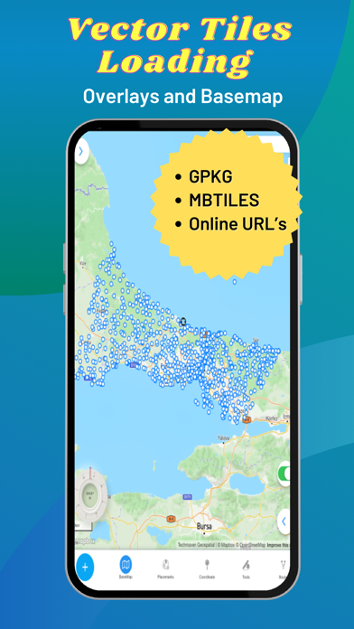
Supports user loaded device GeoJSON,Raster tiles from MBTILES and GPKG and vector tiles from MBTILES.
Supports user loaded Map Catalog (JSON) of internet mapping content (with catalog building screen)
XYZ PNG/JPG Raster Tiles
PBF Vector Tiles
GeoJSON
Local map tiles in mbtiles and gpkg
Includes additional layers users can enable:
vector overlays (Reference Grids, TimeZones and US State Boundaries)
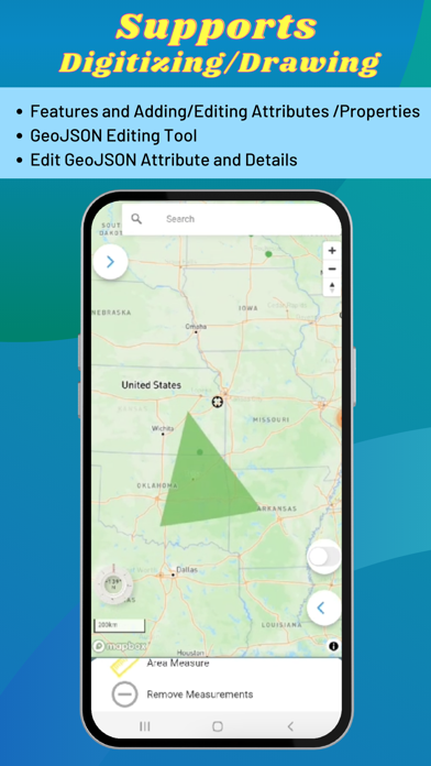
Draw/digitize vector data and support editing and assigning attributes.
Map Supports Tilting to display 3D terrain and 3D Buildings (only some basemaps support 3D buildings )
Currently, terrain is not available offline.
Map Tools:
- Search - places, addresses
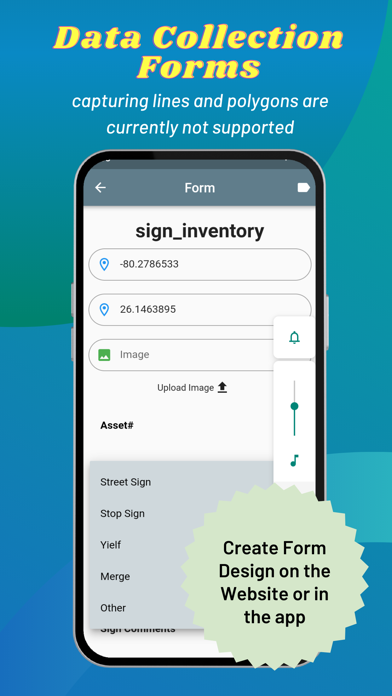
- Advanced dynamic data collection forms with form builder
- Draw/Digitize Data Creation and Editing and export as GeoJSON
- Information Box for geojson data
- Measure linear and Area
- Geolocation & Coordinate Widget (Lat Long and MGRS and zoom level) and share location
- Go to Lat Long
- Placemarks (spatial bookmarks) (with import and export of Waypoints GeoJSON, KML and GPX)
- Basic Route Planning with import of Waypoints (KML and GPX)
- Connection to other Navigation Apps
- GPS Recorder with background recording and export or track
- View Spot Elevation
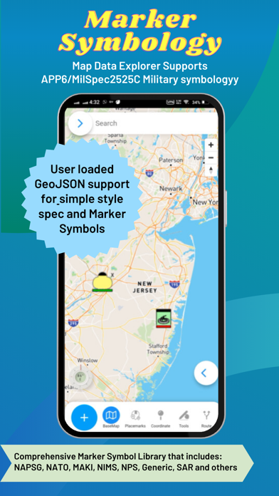
- Display Military Symbology (App6/MilSpec2525C) GeoJSON Schema easily shared with other apps
- Radius Ruler/Range Rings
- Coordinate Converter (to/from projected coordinates or geographic and GRIDS - MGRS, GARS, WHAT3WORD)
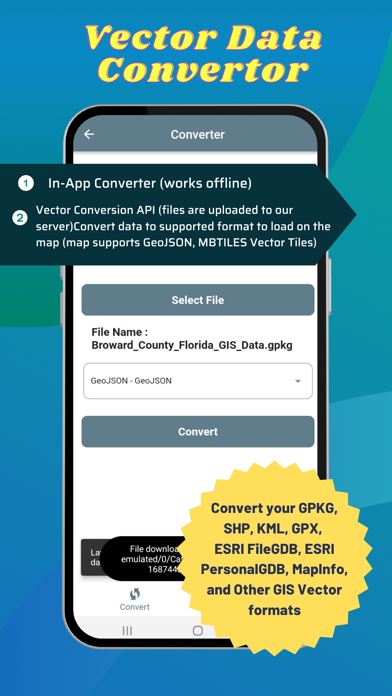
Includes an in-app vector converter to convert GIS data (Shapefiles, GPKG, GPX, KML, CSV, WKT to GeoJSON) must be 4326
Includes in-app coordinate converter to convert to /from different coordinate systems and GRIDS (MGRS,GARS, etc)
Wifi Sharing - access device files from web browser
File Manager To manage files
Create Forms with in-app or web form designer with JSON Schema
Load a form design and swap between forms
Collect any form data
Other features:
Vector Conversion and Publishing API to convert local vector GIS Data and also publish to PostGIS database tables.
Added Button links to TMG Map Data Explorer website for all in-app purchase screen
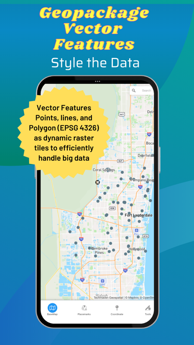
Serve OGC GPKG -GeoPackage with Vector Tiles new OGC extensions
Support for any SRS for raster tiles in GPKG (tested with 3857 and 3395)
Support for any SRS for Vector Tiles in GPKG (tested with 3857 and 3395)
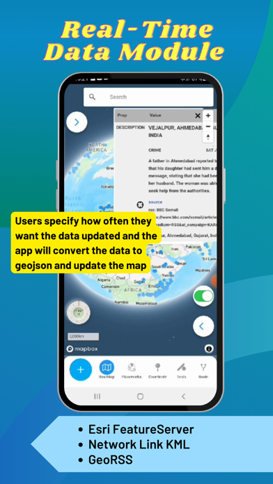
Real-Time Data Module (Network Link KML and Internet KML, ESRI GeoServices REST API and GeoRSS) display on the map and update at set frequency
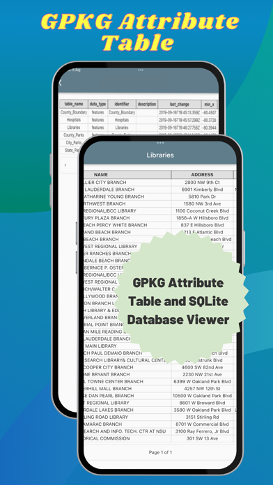
Button to view attributes from GPKG Vector Features
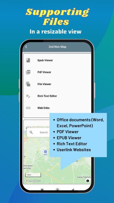
2nd Non Map View – Office documents (Word, Excel, Powerpoint), PDF Viewer, EPUB Viewer, User links web pages and File Manager
User loaded GeoJSON support for simple style spec and Marker Symbols
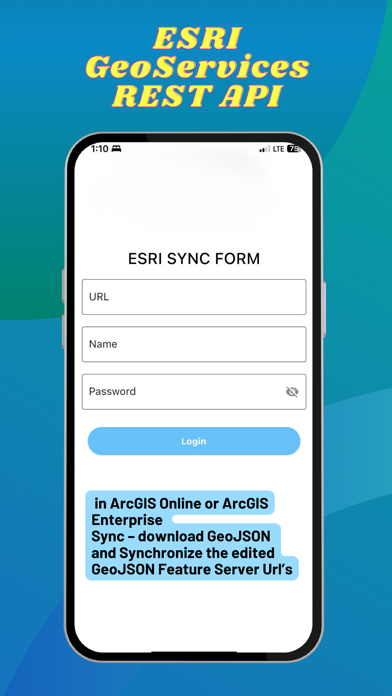
ESRI GeoServices REST API (FeatureServer) in ArcGIS Online or ArcGIS Enterprise Sync – download GeoJSON and Synchronize edited GeoJSON.
Elevate API - submit geojson point and return back with Elevation, MGRS, GARS, What3Words, PlaceKey, Pluscode properties
GeoRequest Area of Interest API for submitting jobs for offline data
Pre-staged data downloading of ready to download data
Area of interest downloading of online map data:
Tile Downloader that supports building mbtiles from tile layers (XYZ/TMS, WMTS and Dynamic and cached mapping services (ESRI MapServer, ImageServer, OGC WMS) and downloading GeoJSON from WFS and MapServer and FeatureServer.
Terms of Use: https://mapexplorer.techmaven.net/eula/
Supports user loaded device GeoJSON,Raster tiles from MBTILES and GPKG and vector tiles from MBTILES.
Supports user loaded Map Catalog (JSON) of internet mapping content (with catalog building screen)
XYZ PNG/JPG Raster Tiles
PBF Vector Tiles
GeoJSON
Local map tiles in mbtiles and gpkg
Includes additional layers users can enable:
vector overlays (Reference Grids, TimeZones and US State Boundaries)
Draw/digitize vector data and support editing and assigning attributes.
Map Supports Tilting to display 3D terrain and 3D Buildings (only some basemaps support 3D buildings )
Currently, terrain is not available offline.
Map Tools:
- Search - places, addresses
- Advanced dynamic data collection forms with form builder
- Draw/Digitize Data Creation and Editing and export as GeoJSON
- Information Box for geojson data
- Measure linear and Area
- Geolocation & Coordinate Widget (Lat Long and MGRS and zoom level) and share location
- Go to Lat Long
- Placemarks (spatial bookmarks) (with import and export of Waypoints GeoJSON, KML and GPX)
- Basic Route Planning with import of Waypoints (KML and GPX)
- Connection to other Navigation Apps
- GPS Recorder with background recording and export or track
- View Spot Elevation
- Display Military Symbology (App6/MilSpec2525C) GeoJSON Schema easily shared with other apps
- Radius Ruler/Range Rings
- Coordinate Converter (to/from projected coordinates or geographic and GRIDS - MGRS, GARS, WHAT3WORD)
Includes an in-app vector converter to convert GIS data (Shapefiles, GPKG, GPX, KML, CSV, WKT to GeoJSON) must be 4326
Includes in-app coordinate converter to convert to /from different coordinate systems and GRIDS (MGRS,GARS, etc)
Wifi Sharing - access device files from web browser
File Manager To manage files
Create Forms with in-app or web form designer with JSON Schema
Load a form design and swap between forms
Collect any form data
Other features:
Vector Conversion and Publishing API to convert local vector GIS Data and also publish to PostGIS database tables.
Added Button links to TMG Map Data Explorer website for all in-app purchase screen
Serve OGC GPKG -GeoPackage with Vector Tiles new OGC extensions
Support for any SRS for raster tiles in GPKG (tested with 3857 and 3395)
Support for any SRS for Vector Tiles in GPKG (tested with 3857 and 3395)
Real-Time Data Module (Network Link KML and Internet KML, ESRI GeoServices REST API and GeoRSS) display on the map and update at set frequency
Button to view attributes from GPKG Vector Features
2nd Non Map View – Office documents (Word, Excel, Powerpoint), PDF Viewer, EPUB Viewer, User links web pages and File Manager
User loaded GeoJSON support for simple style spec and Marker Symbols
ESRI GeoServices REST API (FeatureServer) in ArcGIS Online or ArcGIS Enterprise Sync – download GeoJSON and Synchronize edited GeoJSON.
Elevate API - submit geojson point and return back with Elevation, MGRS, GARS, What3Words, PlaceKey, Pluscode properties
GeoRequest Area of Interest API for submitting jobs for offline data
Pre-staged data downloading of ready to download data
Area of interest downloading of online map data:
Tile Downloader that supports building mbtiles from tile layers (XYZ/TMS, WMTS and Dynamic and cached mapping services (ESRI MapServer, ImageServer, OGC WMS) and downloading GeoJSON from WFS and MapServer and FeatureServer.
Terms of Use: https://mapexplorer.techmaven.net/eula/
Map Data Explorer স্ক্রিনশট


Map Data Explorer এর মতো অ্যাপ
 DUM Data usage manager-Track network data usage,Monitor mobile data plan manager4.1
 Map Data Explorer2.0
 Map Map - Your Map on a Map5.0
 Satellite Map ( Non Cellular Data Offline Map And GPS Logger )-
 Data Explorer4.9
 Edelog Data Explorer-
 Personal Data Explorer3.6
 Taxpayer Data Explorer-
 Data Explorer for Spotify-
 Bahrain Data Explorer-
 Clean Explorer - Block ads, Surf faster, Save Data-
 Data Workshop— AI Data Crowdso-
Map Data Explorer FAQ
আমি কিভাবে Map Data Explorer পিজিয়ার এপিকে হাব থেকে ডাউনলোড করব?
পিজিয়ার এপিকে হাবে Map Data Explorer ডাউনলোড করার জন্য কোন খরচ আছে?
পিজিয়ার এপিকে হাব থেকে Map Data Explorer ডাউনলোড করতে কি আমার একটি অ্যাকাউন্ট দরকার?
পিজিয়ার এপিকে হাব থেকে Map Data Explorer সমস্যা রিপোর্ট করতে কিভাবে পারি?
আপনি কি এটা সাহায্যকর পেয়েছেন
হ্যাঁ
না
সবচেয়ে জনপ্রিয়
Sing It - Ear TrainerA must app for every musician, singer, or just for fun.
Test,train, and improve your musical ear an
Tube PiP - PiP for YouTubeTube PiP - the ultimate YouTube companion for iOS:
1. Picture in Picture (PiP) Playback: Watch YouT
Papaya Ouch!In the game Papaya Ouch!, you can experience backpack management, tower defense, TD, merge, match 2,
Lets Go VPNLets Go VPN, the most advanced VPN, is designed by a team of top developers who strive to ensure all
Paprika Recipe Manager 3Organize your recipes. Create grocery lists. Plan your meals. Download recipes from your favorite we
War Pigeons UnboundedWar is coming. Deep down in top secret military labs they have evolved, mutated - and escaped. The f
Procreate PocketApp of the Year winner Procreate Pocket is the most feature-packed and versatile art app ever design
Cowboy Westland survival runAre you ready to take part in the #1 exciting 3D western adventure? Cowboy Westland survival run mak
Max: Stream HBO, TV, & MoviesIt’s all here. Iconic series, award-winning movies, fresh originals, and family favorites, featuring
TonalEnergy Tuner & MetronomeFor musicians from pros to beginners, whether you sing, play a brass, woodwind or stringed instrumen
SkyView®SkyView® brings stargazing to everyone. Simply point your iPhone, iPad, or iPod at the sky to identi
Ninja Dash 2015Ninja Dash 2015 is the fast paced running game!<br>On these maze fields, rush to the end of this nin
Tami-Live Chat&VideoTami is an app that records daily life and ideas.<br><br>You can use it to record your every day, wh
SALE Camera - marketing camera effects plus photo editorSALE Camera Help you create the best Business to consumer Stock Photos and Images. provides 300 filt
DevTutor for SwiftUI"DevTutor" is an application designed to assist developers in creating exceptional apps using SwiftU
Mokens League SoccerDive into Mokens League Soccer and experience the new era of soccer gaming!
Esports for Everyone: W
Zombie ZZOMBIE ENDLESS RUNNER LIKES NO OTHER!<br><br>WHY?<br><br>* Awesome graphic quality!<br><br>* Simplif
Dead Z - Zombie SurvivalCatastrophic explosion at the Omega Labs started the apocalypse, now spreading across the Earth.
Ta
HotSchedulesHotSchedules is the industry's leading employee scheduling app because it’s the fastest and easiest
ChatGPTIntroducing ChatGPT for iOS: OpenAI’s latest advancements at your fingertips.
This official app is
Disney StoreDisney Store is your official home for exclusive collections, designer collaborations, and one-of-a-
fight back tennisa Pong game with Tennis style, the gameplay itself is very simple, you can using Touch. Ball speed w
Dr. Mina AdlyMina Adly mobile app provides students with portable instant access to a selection of services.
Usi
iVerify BasiciVerify Basic is your gateway to enhanced device security and threat awareness, offering a glimpse i