Photo To Mapについて
Download PhotoToMap today and unlock the full potential of your photos by transforming them into stunning maps with comprehensive EXIF information!
If you subscribe to our app you will be able to export the EXIF data of multiple photos in Excel and GIS formats, visualize the position and distance between the photos on a map in HTML format. All maps with positioned photos are available for embedding in your applications.
With this app you can make:
1. Multiple Image Import: Easily import multiple photos from your device's gallery or camera roll with just a few taps
2. Map Generation: Automatically extract the EXIF coordinates from your photos and create a map that pinpoints the exact locations where your photos were taken. You can choose from different map styles, such as satellite, terrain, or street view, to customize the visual presentation of your map
3. Export image info in various formats: HTML Map, HTML Table, CSV, Excel, JSON, GeoJSON, Shape, KML, GPX and DXF
4. Excel Sheet Creation: PhotoToMap automatically generates an Excel sheet with comprehensive EXIF information for each photo, including the date, time, camera model, exposure settings, and more. This feature is particularly useful for professional photographers or anyone who wants to keep track of detailed information about their photos
User-friendly Interface: PhotoToMap is designed with a clean and intuitive interface, making it easy for users of all skill levels to navigate and use the app effectively
Use Cases:
1. Travel Enthusiasts: Create stunning maps of your travel photos and share them with your friends and family to showcase your adventures around the world.
2. Outdoor Adventurers: Track your hiking, biking, or camping trips by importing your photos and visualizing your routes on a map.
3. Real Estate Professionals: Create maps of property listings with photos taken at different locations to give potential buyers a clear understanding of the property's location and surroundings. Share the maps in your listings to provide an immersive visual experience for potential buyers and help them make informed decisions.
4. Archaeologists or Field Researchers: Use PhotoToMap to document the coordinates of artifacts, excavation sites, or research locations, and export the data as shapefiles or KML files for further analysis.
5. Photography Enthusiasts: Keep track of your photography portfolio by creating maps that highlight the locations where your best shots were taken, and export EXIF information for record-keeping or portfolio management purposes.
Requirements:
- iOS devices using iOS 16 or later
- The app requires internet access over a Wi Fi or mobile data connection
We offer auto-renewing subscriptions with the following terms:
- Subscriptions are 1 month, 6 months or 12 months long
- Payment will be charged to Apple ID Account at confirmation of purchase
- Subscription automatically renews unless auto renew is turned off at least 24-hours before the end of the current period
- Your account will be charged for renewal within 24-hours prior to the end of the current period, and the cost of the renewal will be identified
- Subscriptions may be managed by the user and auto-renewal may be turned off by going to the user's Account Settings after purchase
- No cancellation of the current subscription is allowed during active subscription period
- Any unused portion of a free trial period, if offered, will be forfeited when you purchase a subscription, where applicable.
By using the app, you are agreeing to our Privacy Policy and Terms of use:
https://gisgp.com/phototomap/privacypolicy.html
https://gisgp.com/phototomap/termofuse.html
If you have any questions please contact us at support@gisgp.com
Photo To Map スクリーンショット
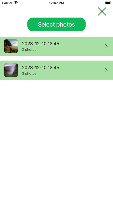
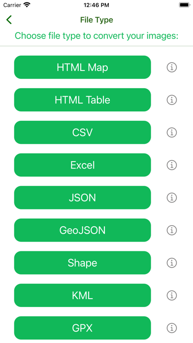
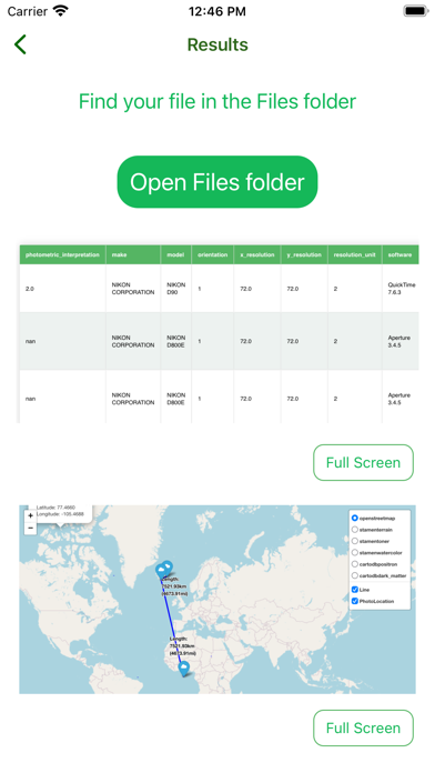
Photo To Map iPad スクリーンショット
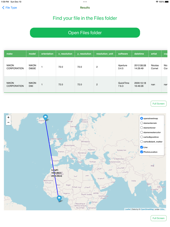
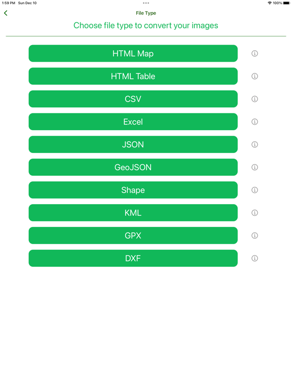
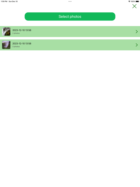


Photo To Map と似たアプリ
 Map Map - Your Map on a Map5.0
 Photo Texter - text on photo, shape on photo, filter photo, watermark maker-
 Cute Pink Photo Collage Maker: Adorable photo editor for girls with lots of photo frames, background color themes and photo filters-
 HD Hoarding Theme Photo Frame Editor and Collage Maker - Photo Lab Foto Montage with Colorful Frame. Feel yourself rich & celebrity with PicCells Instaceleb Wonder photo candy & photo studio app.-
 ImageEditor-Free photo Editor With Photo effects,blur effects,photo crop,photo adjustments-
 Frankfurt Offline Map(offline map, subway map, GPS, tourist attractions information)-
 Yokohama Offline Map(offline map, subway map, GPS, tourist attractions information)-
 Los Angeles Offline Map(offline map, subway map, GPS, tourist attractions information)-
 Kaohsiung Offline Map(offline map, subway map, GPS, tourist attractions information)-
 Kuala Lumpur Offline Map(offline map, subway map, GPS, tourist attractions information)-
 Brussels Offline Map(offline map, subway map, GPS, tourist attractions information)-
 Taipei Offline Map(offline map, subway map)-
最も人気のある
Sing It - Ear TrainerA must app for every musician, singer, or just for fun.
Test,train, and improve your musical ear an
Tube PiP - PiP for YouTubeTube PiP - the ultimate YouTube companion for iOS:
1. Picture in Picture (PiP) Playback: Watch YouT
Papaya Ouch!In the game Papaya Ouch!, you can experience backpack management, tower defense, TD, merge, match 2,
Lets Go VPNLets Go VPN, the most advanced VPN, is designed by a team of top developers who strive to ensure all
Paprika Recipe Manager 3Organize your recipes. Create grocery lists. Plan your meals. Download recipes from your favorite we
War Pigeons UnboundedWar is coming. Deep down in top secret military labs they have evolved, mutated - and escaped. The f
Procreate PocketApp of the Year winner Procreate Pocket is the most feature-packed and versatile art app ever design
Cowboy Westland survival runAre you ready to take part in the #1 exciting 3D western adventure? Cowboy Westland survival run mak
Max: Stream HBO, TV, & MoviesIt’s all here. Iconic series, award-winning movies, fresh originals, and family favorites, featuring
TonalEnergy Tuner & MetronomeFor musicians from pros to beginners, whether you sing, play a brass, woodwind or stringed instrumen
SkyView®SkyView® brings stargazing to everyone. Simply point your iPhone, iPad, or iPod at the sky to identi
Ninja Dash 2015Ninja Dash 2015 is the fast paced running game!<br>On these maze fields, rush to the end of this nin
Tami-Live Chat&VideoTami is an app that records daily life and ideas.<br><br>You can use it to record your every day, wh
SALE Camera - marketing camera effects plus photo editorSALE Camera Help you create the best Business to consumer Stock Photos and Images. provides 300 filt
DevTutor for SwiftUI"DevTutor" is an application designed to assist developers in creating exceptional apps using SwiftU
Mokens League SoccerDive into Mokens League Soccer and experience the new era of soccer gaming!
Esports for Everyone: W
Zombie ZZOMBIE ENDLESS RUNNER LIKES NO OTHER!<br><br>WHY?<br><br>* Awesome graphic quality!<br><br>* Simplif
Dead Z - Zombie SurvivalCatastrophic explosion at the Omega Labs started the apocalypse, now spreading across the Earth.
Ta
HotSchedulesHotSchedules is the industry's leading employee scheduling app because it’s the fastest and easiest
ChatGPTIntroducing ChatGPT for iOS: OpenAI’s latest advancements at your fingertips.
This official app is
Disney StoreDisney Store is your official home for exclusive collections, designer collaborations, and one-of-a-
fight back tennisa Pong game with Tennis style, the gameplay itself is very simple, you can using Touch. Ball speed w
Dr. Mina AdlyMina Adly mobile app provides students with portable instant access to a selection of services.
Usi
iVerify BasiciVerify Basic is your gateway to enhanced device security and threat awareness, offering a glimpse i