Planimeter GPS Area Measure
4.2रेटिंग
Aug 27, 2024नवीनतम अपडेट
2.1.15संस्करण
Planimeter GPS Area Measure के बारे में
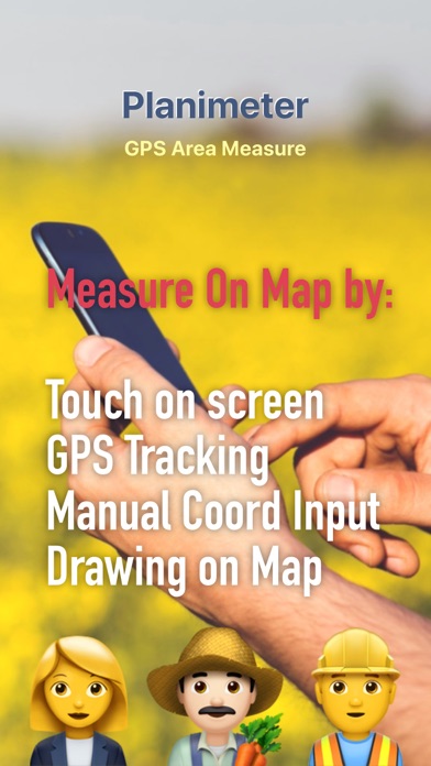
Planimeter is a tool to measure distance, area and perimeter on a map. You can measure manually or by GPS tracking. You can also check the bearing and geo-coordinates of your location and share it. Points can be labeled, saved and shared in KML format.
This measurement app is useful for outdoor activities and can be used as land surveyor by amateurs and professionals in various industries like sport, farming, landscaping, paving and construction, road building and repairing, real estate business, hiking and travel, fencing, lot building and planning, solar panel installation (roof area estimation), object mapping, lawn design, and many other where land area and distance / length calculations, land survey or maps are involved.
If you have any question about Planimeter and its functionality, please check How To Use Quick Guide:
http://ios.vistechprojects.com/Planimeter_iOS_QuickGuide.pdf
Video Demo:
http://youtu.be/unjYbPCIYM0
http://youtu.be/QQMilHVD5e8
Features:
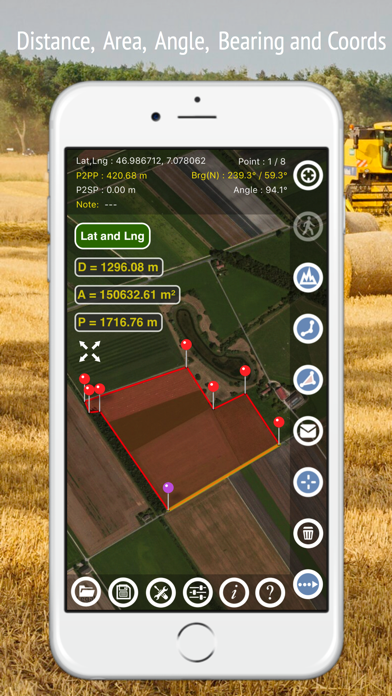
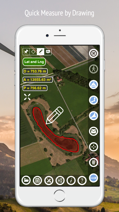
Accurate distance and area calculation
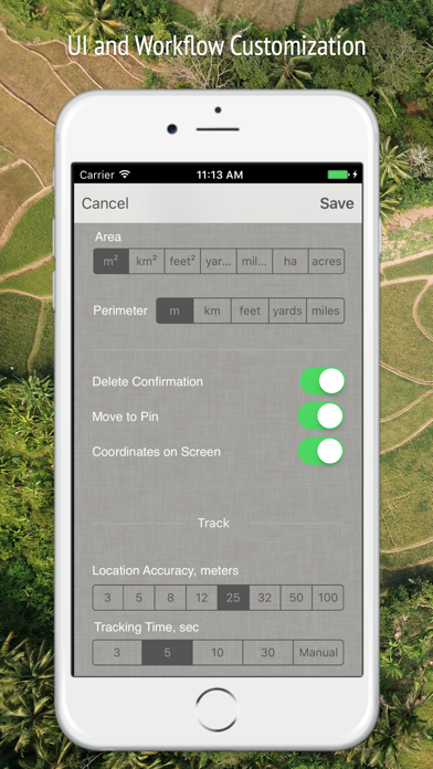
Metric and Imperial units (m, km, feet, yards, miles, ha, acres)
Angle between lines
Bearings To and From the point
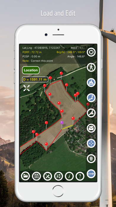
Forth and Back navigation through points by touch on Info Panel
GPS coordinates of a point
GPS accuracy settings (if GPS available)
Manage previously saved projects: open, save, share KML files
KML files created by Planimeter can be imported to GEarth and GMaps to view on a desktop
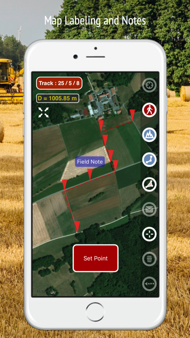
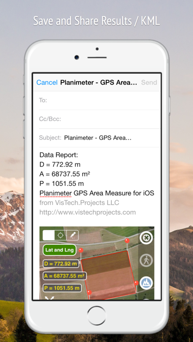
Send data by email: picture, coordinates as text message, KML file
Save KML or TXT in local storage
Map/Satellite View
Zoom and Edit points
Current location search
Text (address) search
Delete selected/last/all points
Zoom to Fit-in and center points on a screen - quick points search
Add points by touch
Add current location as a point
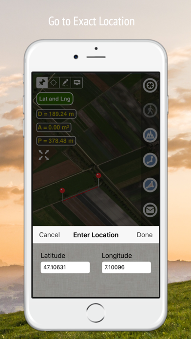
Show location with Latitude and Longitude coordinates
Add points by Geo-coordinates: Lat and Lng
Option to center last point added
Option to show/hide lines
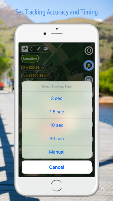
Preferences: location accuracy, tracking time interval, delete points confirmation, sound option for tracking
Separate units settings for distance, area, perimeter
Target Mode for accurate pin placement
Show current coordinates in Target Mode
Stylus Draw Mode
Full-screen option
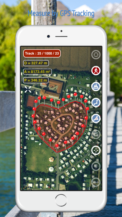
GPS TRACKING
Manual pin placement in GPS Tracking
The app has been successfully used in different areas:
- outdoor activities: sports, golf (distance between two points or holes), bike tours, trail planning, travelling, quick path measure
- garden and yard: landscape planning, grass cutting, lawn care and mowing, fencing, grass seeding.
- agriculture, poultry and farming: harvesting, fertilizing, crops (corn, wheat, maize, beet, etc.) planning and estimation, field area measure, paddocks and area fencing for cows, horses, chickens, rabbits, etc.
- solar energy: area estimation for solar panels, flat roof area estimation
- construction: land survey, road sealing, parking lot repairing
- forestry: objects and tree mapping, damage area estimation, measure land area
- other: ponds size and are measure; pole lines planning; movement tracking; get exact GPS coordinates of way-points; fence calculation; geocaching.
Note: Continued use of GPS running in the background can dramatically decrease battery life.
If you like the app and find it useful please support us with your feedback and comment.
Feel free to contact support@vistechprojects.com with any questions, comments or bug reports.
This measurement app is useful for outdoor activities and can be used as land surveyor by amateurs and professionals in various industries like sport, farming, landscaping, paving and construction, road building and repairing, real estate business, hiking and travel, fencing, lot building and planning, solar panel installation (roof area estimation), object mapping, lawn design, and many other where land area and distance / length calculations, land survey or maps are involved.
If you have any question about Planimeter and its functionality, please check How To Use Quick Guide:
http://ios.vistechprojects.com/Planimeter_iOS_QuickGuide.pdf
Video Demo:
http://youtu.be/unjYbPCIYM0
http://youtu.be/QQMilHVD5e8
Features:
Accurate distance and area calculation
Metric and Imperial units (m, km, feet, yards, miles, ha, acres)
Angle between lines
Bearings To and From the point
Forth and Back navigation through points by touch on Info Panel
GPS coordinates of a point
GPS accuracy settings (if GPS available)
Manage previously saved projects: open, save, share KML files
KML files created by Planimeter can be imported to GEarth and GMaps to view on a desktop
Send data by email: picture, coordinates as text message, KML file
Save KML or TXT in local storage
Map/Satellite View
Zoom and Edit points
Current location search
Text (address) search
Delete selected/last/all points
Zoom to Fit-in and center points on a screen - quick points search
Add points by touch
Add current location as a point
Show location with Latitude and Longitude coordinates
Add points by Geo-coordinates: Lat and Lng
Option to center last point added
Option to show/hide lines
Preferences: location accuracy, tracking time interval, delete points confirmation, sound option for tracking
Separate units settings for distance, area, perimeter
Target Mode for accurate pin placement
Show current coordinates in Target Mode
Stylus Draw Mode
Full-screen option
GPS TRACKING
Manual pin placement in GPS Tracking
The app has been successfully used in different areas:
- outdoor activities: sports, golf (distance between two points or holes), bike tours, trail planning, travelling, quick path measure
- garden and yard: landscape planning, grass cutting, lawn care and mowing, fencing, grass seeding.
- agriculture, poultry and farming: harvesting, fertilizing, crops (corn, wheat, maize, beet, etc.) planning and estimation, field area measure, paddocks and area fencing for cows, horses, chickens, rabbits, etc.
- solar energy: area estimation for solar panels, flat roof area estimation
- construction: land survey, road sealing, parking lot repairing
- forestry: objects and tree mapping, damage area estimation, measure land area
- other: ponds size and are measure; pole lines planning; movement tracking; get exact GPS coordinates of way-points; fence calculation; geocaching.
Note: Continued use of GPS running in the background can dramatically decrease battery life.
If you like the app and find it useful please support us with your feedback and comment.
Feel free to contact support@vistechprojects.com with any questions, comments or bug reports.
Planimeter GPS Area Measure स्क्रीनशॉट


Planimeter GPS Area Measure जैसे ऐप्स
 Planimeter 2 GPS area measure2.3
 Planimeter GPS Area Measure4.2
 map measure planimeter : land area and distance3.3
 Planimeter — Measure Land Area4.8
 Planimeter 55. Measure on map.4.5
 Planimeter for map measure4.4
 Planimeter Pro for map measure4.3
 Planimeter: Map Measure4.6
 Geo Planimeter - Area & Distance Calculator1.0
 GPS Field Area Measure GPS Map-
 Hectare field area measure GPS2.8
 GPS Fields Area Measure On Map4.5
VisTech.Projects LLC द्वारा ऐप्स
 Unit Converter | Converter4U4.6
 Pupillary Distance Measure X4.5
 Millimeter Pro - screen ruler4.4
- Planimeter GPS Area Measure4.2
 Face Shape Meter camera tool4.1
 SolarMeter sun energy planner4.0
 Partometer - camera measure3.8
 Partometer3D measure on photo3.7
 The Ring Sizer | Converter3.7
 Pupillary Distance Measure3.0
- Planimeter 2 GPS area measure2.3
 PD Measure Ruler2.0
Planimeter GPS Area Measure FAQ
मैं PGYER IPA HUB से Planimeter GPS Area Measure कैसे डाउनलोड करूं?
PGYER IPA HUB पर Planimeter GPS Area Measure मुफ्त डाउनलोड करने के लिए है?
PGYER IPA HUB से Planimeter GPS Area Measure डाउनलोड करने के लिए मुझे एक खाता चाहिए?
मैं PGYER IPA HUB पर Planimeter GPS Area Measure के साथ समस्या कैसे रिपोर्ट कर सकता हूँ?
क्या आपको यह मददगार पाया
हाँ
नहीं
सबसे लोकप्रिय
Sing It - Ear TrainerA must app for every musician, singer, or just for fun.
Test,train, and improve your musical ear an
Tube PiP - PiP for YouTubeTube PiP - the ultimate YouTube companion for iOS:
1. Picture in Picture (PiP) Playback: Watch YouT
Papaya Ouch!In the game Papaya Ouch!, you can experience backpack management, tower defense, TD, merge, match 2,
Lets Go VPNLets Go VPN, the most advanced VPN, is designed by a team of top developers who strive to ensure all
Paprika Recipe Manager 3Organize your recipes. Create grocery lists. Plan your meals. Download recipes from your favorite we
War Pigeons UnboundedWar is coming. Deep down in top secret military labs they have evolved, mutated - and escaped. The f
Procreate PocketApp of the Year winner Procreate Pocket is the most feature-packed and versatile art app ever design
Cowboy Westland survival runAre you ready to take part in the #1 exciting 3D western adventure? Cowboy Westland survival run mak
Max: Stream HBO, TV, & MoviesIt’s all here. Iconic series, award-winning movies, fresh originals, and family favorites, featuring
TonalEnergy Tuner & MetronomeFor musicians from pros to beginners, whether you sing, play a brass, woodwind or stringed instrumen
SkyView®SkyView® brings stargazing to everyone. Simply point your iPhone, iPad, or iPod at the sky to identi
Ninja Dash 2015Ninja Dash 2015 is the fast paced running game!<br>On these maze fields, rush to the end of this nin
Tami-Live Chat&VideoTami is an app that records daily life and ideas.<br><br>You can use it to record your every day, wh
SALE Camera - marketing camera effects plus photo editorSALE Camera Help you create the best Business to consumer Stock Photos and Images. provides 300 filt
DevTutor for SwiftUI"DevTutor" is an application designed to assist developers in creating exceptional apps using SwiftU
Mokens League SoccerDive into Mokens League Soccer and experience the new era of soccer gaming!
Esports for Everyone: W
Zombie ZZOMBIE ENDLESS RUNNER LIKES NO OTHER!<br><br>WHY?<br><br>* Awesome graphic quality!<br><br>* Simplif
Dead Z - Zombie SurvivalCatastrophic explosion at the Omega Labs started the apocalypse, now spreading across the Earth.
Ta
HotSchedulesHotSchedules is the industry's leading employee scheduling app because it’s the fastest and easiest
ChatGPTIntroducing ChatGPT for iOS: OpenAI’s latest advancements at your fingertips.
This official app is
Disney StoreDisney Store is your official home for exclusive collections, designer collaborations, and one-of-a-
fight back tennisa Pong game with Tennis style, the gameplay itself is very simple, you can using Touch. Ball speed w
Dr. Mina AdlyMina Adly mobile app provides students with portable instant access to a selection of services.
Usi
iVerify BasiciVerify Basic is your gateway to enhanced device security and threat awareness, offering a glimpse i