opti*Map 2024
5Valutazione
Aug 24, 2024Ultimo aggiornamento
3.40cVersione
Come installare il file .IPA
Condividi
Informazioni su opti*Map 2024
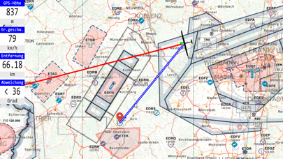
////// opti*Map is the digital ICAO chart for Germany //////
opti*Map is a cost-effective alternative to the printed ICAO charts of the German Air Traffic Control (DFS), which are usually used as backup for flights according to visual flight rules. The digital chart material is considerably clearer and more user-friendly than the large printed chart sheets. Who hasn't experienced that a lot of attention is lost when folding and, in the end, the unwieldy ball of paper doesn't fit into the side pocket anymore? Not to mention "flying over the edge of the map".
With opti*Map you can zoom, move and rotate the map continuously. The clarity is always maintained, because when zooming, it automatically switches between a total of five different levels of detail. When displaying the complete map sheet, only the most important airspaces, country borders and FIR areas are shown. If you zoom further and further into the map, more airspaces and the airfields are displayed. At the next level of detail, additional VORs, forest areas and roads appear. Finally, mandatory reporting points, the frequencies of the airfields and the altitude of the airspaces appear.
However, opti*Map is much more than a digital ICAO map on a smartphone or tablet. Namely, it also shows the current position and it can be used to navigate to target points. The map can be displayed "North-up", "Track-up" or "Goal-up". If the map is shifted very far, so that the aircraft symbol is no longer visible, it is sufficient to press the center key to display the current position again.
In addition to the digital ICAO chart, the airspace data of the DAeC are also displayed in Germany. In the altitude view, the start and end of the glider flight can be set.
All flights are saved and can be recalled. This even works during a flight!
Data tiles, which can be shown and hidden if desired, display important data. For example the speed over ground and the distance as well as deposit to the target. opti*Map optimizes the flights according to the WeGlide rules and calculates the wind very quickly.
opti*Map is updated significantly more often than a printed ICAO chart. All updates and feature enhancements are free of charge during the calendar year.
More information is available here in German language (please translate in Browers): https://opti-map.de
Screenshot di opti*Map 2024


Più popolare
Sing It - Ear TrainerA must app for every musician, singer, or just for fun.
Test,train, and improve your musical ear an
Tube PiP - PiP for YouTubeTube PiP - the ultimate YouTube companion for iOS:
1. Picture in Picture (PiP) Playback: Watch YouT
Papaya Ouch!In the game Papaya Ouch!, you can experience backpack management, tower defense, TD, merge, match 2,
Lets Go VPNLets Go VPN, the most advanced VPN, is designed by a team of top developers who strive to ensure all
Paprika Recipe Manager 3Organize your recipes. Create grocery lists. Plan your meals. Download recipes from your favorite we
War Pigeons UnboundedWar is coming. Deep down in top secret military labs they have evolved, mutated - and escaped. The f
Procreate PocketApp of the Year winner Procreate Pocket is the most feature-packed and versatile art app ever design
Cowboy Westland survival runAre you ready to take part in the #1 exciting 3D western adventure? Cowboy Westland survival run mak
Max: Stream HBO, TV, & MoviesIt’s all here. Iconic series, award-winning movies, fresh originals, and family favorites, featuring
TonalEnergy Tuner & MetronomeFor musicians from pros to beginners, whether you sing, play a brass, woodwind or stringed instrumen
SkyView®SkyView® brings stargazing to everyone. Simply point your iPhone, iPad, or iPod at the sky to identi
Ninja Dash 2015Ninja Dash 2015 is the fast paced running game!<br>On these maze fields, rush to the end of this nin
Tami-Live Chat&VideoTami is an app that records daily life and ideas.<br><br>You can use it to record your every day, wh
SALE Camera - marketing camera effects plus photo editorSALE Camera Help you create the best Business to consumer Stock Photos and Images. provides 300 filt
DevTutor for SwiftUI"DevTutor" is an application designed to assist developers in creating exceptional apps using SwiftU
Mokens League SoccerDive into Mokens League Soccer and experience the new era of soccer gaming!
Esports for Everyone: W
Zombie ZZOMBIE ENDLESS RUNNER LIKES NO OTHER!<br><br>WHY?<br><br>* Awesome graphic quality!<br><br>* Simplif
Dead Z - Zombie SurvivalCatastrophic explosion at the Omega Labs started the apocalypse, now spreading across the Earth.
Ta
HotSchedulesHotSchedules is the industry's leading employee scheduling app because it’s the fastest and easiest
ChatGPTIntroducing ChatGPT for iOS: OpenAI’s latest advancements at your fingertips.
This official app is
Disney StoreDisney Store is your official home for exclusive collections, designer collaborations, and one-of-a-
fight back tennisa Pong game with Tennis style, the gameplay itself is very simple, you can using Touch. Ball speed w
Dr. Mina AdlyMina Adly mobile app provides students with portable instant access to a selection of services.
Usi
iVerify BasiciVerify Basic is your gateway to enhanced device security and threat awareness, offering a glimpse i