Hazards and Population Mapper 정보
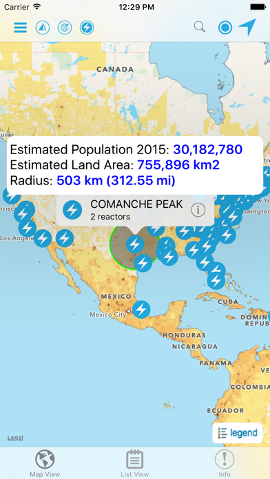
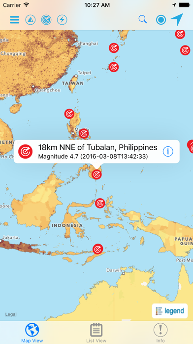
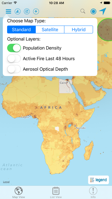
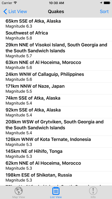
Hazards and Population Mapper (HazPop) is a free app that enables users to easily display recent natural hazard data in relationship to population, major infrastructure, and satellite imagery. Hazards data include the location of active fires over the past 48 hours; earthquake alerts over the past seven days; and yesterday′s air pollution data measured from space. The app shows the location of major dams and nuclear power plants and provides more detailed information and imagery for these facilities where available. By drawing a circle around a point or area of interest on the map, users can obtain an estimate of the total population and land area enclosed within.
Developed by the NASA Socioeconomic Data and Applications Center (SEDAC) operated by the Center for International Earth Science Information Network (CIESIN) at Columbia University, HazPop combines data and map layers from various sources including NASA's Land, Atmosphere Near real-time Capability for EOS (LANCE) and Global Imagery Browse Services (GIBS), the U.S. Geological Survey (USGS), and others using a variety of open Web mapping services. The custom population estimates are provided by the SEDAC Population Estimation Service (PES) based on SEDAC′s Gridded Population of the World, version 4 (GPWv4) data for 2015.
HazPop is designed to be used by disaster risk managers, humanitarian response organizations, public health professionals, journalists, and others needing a quick assessment of the potential dangers posed by a major hazardous event or developing emergency. For example, a disaster response agency can obtain a rough estimate of the population and major facilities near a recent earthquake as an input into response planning. Journalists or students can explore the location of recent wildfires relative to dense populations, roads, terrain, and water bodies. Due to the coarse resolution and varying quality of some of the data, HazPop is not intended to support in-depth risk assessment or location-specific response needs.
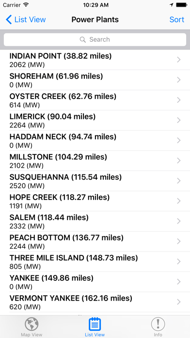
HazPop supports a number of other functions including: Monitoring regions around an area of interest, e.g. hazardous area prone to natural disasters, major infrastructure, or densely populated areas; Sorting dams, nuclear power plants, or earthquakes by proximity to your location or by their characteristics; Determining the distance from your location to any point on the map or between any two points on the map.
Developed by the NASA Socioeconomic Data and Applications Center (SEDAC) operated by the Center for International Earth Science Information Network (CIESIN) at Columbia University, HazPop combines data and map layers from various sources including NASA's Land, Atmosphere Near real-time Capability for EOS (LANCE) and Global Imagery Browse Services (GIBS), the U.S. Geological Survey (USGS), and others using a variety of open Web mapping services. The custom population estimates are provided by the SEDAC Population Estimation Service (PES) based on SEDAC′s Gridded Population of the World, version 4 (GPWv4) data for 2015.
HazPop is designed to be used by disaster risk managers, humanitarian response organizations, public health professionals, journalists, and others needing a quick assessment of the potential dangers posed by a major hazardous event or developing emergency. For example, a disaster response agency can obtain a rough estimate of the population and major facilities near a recent earthquake as an input into response planning. Journalists or students can explore the location of recent wildfires relative to dense populations, roads, terrain, and water bodies. Due to the coarse resolution and varying quality of some of the data, HazPop is not intended to support in-depth risk assessment or location-specific response needs.
HazPop supports a number of other functions including: Monitoring regions around an area of interest, e.g. hazardous area prone to natural disasters, major infrastructure, or densely populated areas; Sorting dams, nuclear power plants, or earthquakes by proximity to your location or by their characteristics; Determining the distance from your location to any point on the map or between any two points on the map.
Hazards and Population Mapper 스크린샷


Hazards and Population Mapper와 비슷한 앱
 Hazards and Population Mapper3.3
 RadarGuru - Road Hazards and Speed Police Live Maps-
 Population Health Alliance Forum-
 Population Collapse4.5
 Population Planner3.5
 Population Simulator-
 SPEEDSim: Spatial Population Dynamics Simulator2.6
 Planting Population Calculator-
 Population Density Calculator-
 Global Population Statistics-
 Guess The Population-
 POPULATION SALON-
Hazards and Population Mapper FAQ
PGYER IPA HUB에서 Hazards and Population Mapper를 다운로드하는 방법은 무엇인가요?
PGYER IPA HUB에서 Hazards and Population Mapper는 무료로 다운로드할 수 있나요?
PGYER IPA HUB에서 Hazards and Population Mapper를 다운로드하려면 계정이 필요한가요?
PGYER IPA HUB에서 Hazards and Population Mapper와 관련된 문제를 신고하는 방법은 무엇인가요?
도움이 되었나요?
예
아니요
가장 인기 있는
Sing It - Ear TrainerA must app for every musician, singer, or just for fun.
Test,train, and improve your musical ear an
Tube PiP - PiP for YouTubeTube PiP - the ultimate YouTube companion for iOS:
1. Picture in Picture (PiP) Playback: Watch YouT
Papaya Ouch!In the game Papaya Ouch!, you can experience backpack management, tower defense, TD, merge, match 2,
Lets Go VPNLets Go VPN, the most advanced VPN, is designed by a team of top developers who strive to ensure all
Paprika Recipe Manager 3Organize your recipes. Create grocery lists. Plan your meals. Download recipes from your favorite we
War Pigeons UnboundedWar is coming. Deep down in top secret military labs they have evolved, mutated - and escaped. The f
Procreate PocketApp of the Year winner Procreate Pocket is the most feature-packed and versatile art app ever design
Cowboy Westland survival runAre you ready to take part in the #1 exciting 3D western adventure? Cowboy Westland survival run mak
Max: Stream HBO, TV, & MoviesIt’s all here. Iconic series, award-winning movies, fresh originals, and family favorites, featuring
TonalEnergy Tuner & MetronomeFor musicians from pros to beginners, whether you sing, play a brass, woodwind or stringed instrumen
SkyView®SkyView® brings stargazing to everyone. Simply point your iPhone, iPad, or iPod at the sky to identi
Ninja Dash 2015Ninja Dash 2015 is the fast paced running game!<br>On these maze fields, rush to the end of this nin
Tami-Live Chat&VideoTami is an app that records daily life and ideas.<br><br>You can use it to record your every day, wh
SALE Camera - marketing camera effects plus photo editorSALE Camera Help you create the best Business to consumer Stock Photos and Images. provides 300 filt
DevTutor for SwiftUI"DevTutor" is an application designed to assist developers in creating exceptional apps using SwiftU
Mokens League SoccerDive into Mokens League Soccer and experience the new era of soccer gaming!
Esports for Everyone: W
Zombie ZZOMBIE ENDLESS RUNNER LIKES NO OTHER!<br><br>WHY?<br><br>* Awesome graphic quality!<br><br>* Simplif
Dead Z - Zombie SurvivalCatastrophic explosion at the Omega Labs started the apocalypse, now spreading across the Earth.
Ta
HotSchedulesHotSchedules is the industry's leading employee scheduling app because it’s the fastest and easiest
ChatGPTIntroducing ChatGPT for iOS: OpenAI’s latest advancements at your fingertips.
This official app is
Disney StoreDisney Store is your official home for exclusive collections, designer collaborations, and one-of-a-
fight back tennisa Pong game with Tennis style, the gameplay itself is very simple, you can using Touch. Ball speed w
Dr. Mina AdlyMina Adly mobile app provides students with portable instant access to a selection of services.
Usi
iVerify BasiciVerify Basic is your gateway to enhanced device security and threat awareness, offering a glimpse i