Hikepack: Clever Hiking Maps
4.4คะแนน
Nov 10, 2024อัปเดตล่าสุด
2.3เวอร์ชัน
เกี่ยวกับ Hikepack: Clever Hiking Maps
Plan ahead, stay on track, explore. Satellite & topo maps, trails, elevations, route planning and navigation. OFFLINE, with just one tap.
ONLY IN HIKEPACK, ALL OFFLINE:
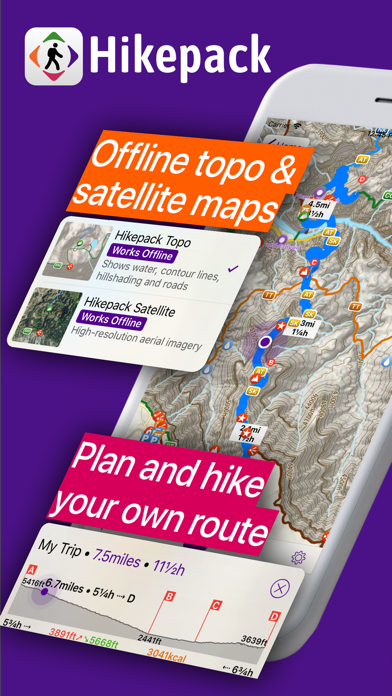
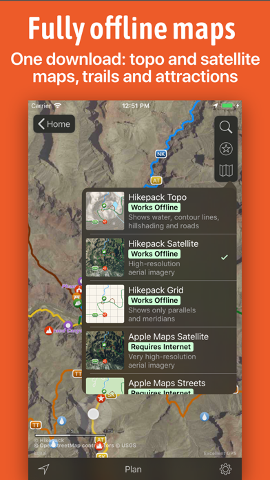
• One download: Trails, peaks and attractions with topo and satellite imagery covering the ENTIRE map.*
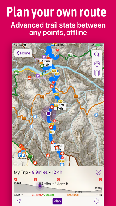
• Planning along trails: Plan your own custom route along existing map trails by simply dropping pins on the map.
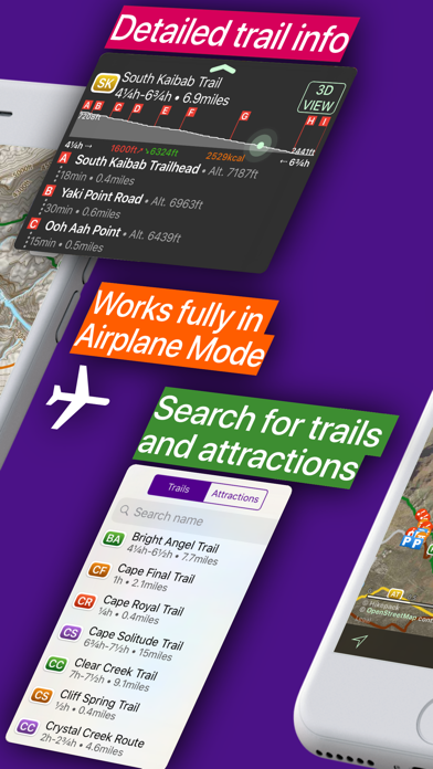
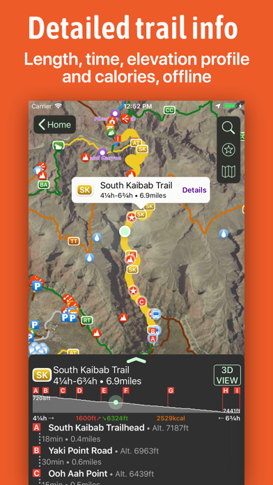
• GPS Navigation: Time, distance, elevation profiles, total ascent, descent, and calories.
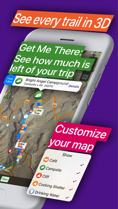
• Get Me There: While hiking, see the remaining time, distance and route to any map symbol or to any dropped pin.
PLAN YOUR TRIP
• See elevation profiles and other advanced trail stats (length, hiking time, ascent/descent, calories)
• Plan your own route, and see the same advanced trail stats also for it
• See the altitude of any point on any route
WHILE YOU HIKE
• See the remaining time and distance to any location, and find the shortest route to it
• See your location on the map
FEATURES IN DETAIL
• Hikepack intelligently extracts all hiking, biking and cross-country ski trails and points of interest from OpenStreetMap data, and packs them into one download. So you have a curated map focused on outdoor activities.
• The topographic and satellite map layers are created by Hikepack, from open data.* They cover the ENTIRE map, which means you're never lost. This is made possible by our proprietary compression algorithms, that allow for a small download and a smooth experience.
• All the routing is done on your device. So if you're in the middle of a hike and without cellular signal, you still see the remaining hiking time and distance to your destination.
• You can save the routes you planned in one map, and then compare their elevation profiles at a glance.
• You can change the hiking speed used for computing hiking time estimates.
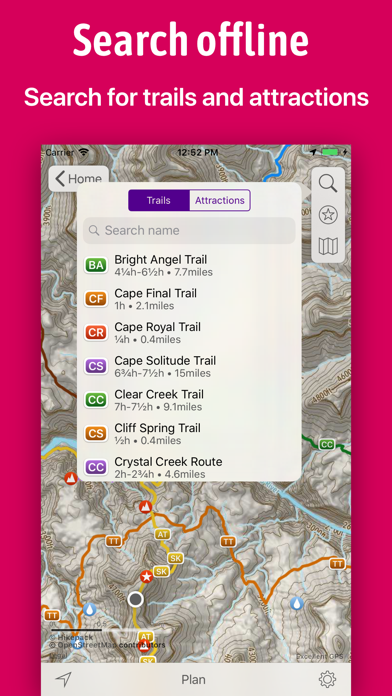
• You can filter what points of interest you see on the map.
• You can measure distances in a straight line, between any points, but they will not take the terrain into account.
••• You can download as many maps as you wish for free offline use, but some features require a Pro Pass subscription.
We're just getting started, and we'd love to hear from you! Suggest new maps or features by sending an e-mail to hello@hikepack.earth, or using the Feedback form in the app.
We regularly publish new maps in Hikepack. Currently, we cover all US national parks: Grand Canyon, Great Smoky, Yosemite, Zion, Rocky Mountain, Yellowstone, Olympic, Acadia, Grand Teton, Glacier, Joshua Tree, Cuyahoga Valley, Bryce Canyon, Hawai'i Volcanoes, Arches, Hot Springs, Shenandoah, Mount Rainier, Death Valley, Haleakala, Sequoia, Capitol Reef, Badlands, Everglades, Saguaro East, Saguaro West, Canyonlands, Crater Lake, Theodore Roosevelt, Petrified Forest, Wind Cave, Kings Canyon, Mammoth Cave, Mesa Verde, Redwood, Lassen Volcanic, Glacier Bay, Carlsbad Caverns, Virgin Islands, Great Sand Dunes, Big Bend, Channel Islands, Kenai Fjords, Voyageurs, Black Canyon of the Gunnison, Pinnacles, Guadalupe Mountains, Great Basin, Congaree, Katmai, North Cascades.
We also cover 40 US national forests, and many other parks, all UK national parks, 35 maps in Finland covering the main hiking areas, from the northern-most parts of Lapland, to popular parks near Helsinki, and 37 maps in Romania covering most of the Carpathian mountains.
----------
* Satellite imagery available only for selected maps in the US and Finland only. The topo layer available for all maps.
** The maps are created by Hikepack from open data. See the details page of each map for the copyright holders.
ONLY IN HIKEPACK, ALL OFFLINE:
• One download: Trails, peaks and attractions with topo and satellite imagery covering the ENTIRE map.*
• Planning along trails: Plan your own custom route along existing map trails by simply dropping pins on the map.
• GPS Navigation: Time, distance, elevation profiles, total ascent, descent, and calories.
• Get Me There: While hiking, see the remaining time, distance and route to any map symbol or to any dropped pin.
PLAN YOUR TRIP
• See elevation profiles and other advanced trail stats (length, hiking time, ascent/descent, calories)
• Plan your own route, and see the same advanced trail stats also for it
• See the altitude of any point on any route
WHILE YOU HIKE
• See the remaining time and distance to any location, and find the shortest route to it
• See your location on the map
FEATURES IN DETAIL
• Hikepack intelligently extracts all hiking, biking and cross-country ski trails and points of interest from OpenStreetMap data, and packs them into one download. So you have a curated map focused on outdoor activities.
• The topographic and satellite map layers are created by Hikepack, from open data.* They cover the ENTIRE map, which means you're never lost. This is made possible by our proprietary compression algorithms, that allow for a small download and a smooth experience.
• All the routing is done on your device. So if you're in the middle of a hike and without cellular signal, you still see the remaining hiking time and distance to your destination.
• You can save the routes you planned in one map, and then compare their elevation profiles at a glance.
• You can change the hiking speed used for computing hiking time estimates.
• You can filter what points of interest you see on the map.
• You can measure distances in a straight line, between any points, but they will not take the terrain into account.
••• You can download as many maps as you wish for free offline use, but some features require a Pro Pass subscription.
We're just getting started, and we'd love to hear from you! Suggest new maps or features by sending an e-mail to hello@hikepack.earth, or using the Feedback form in the app.
We regularly publish new maps in Hikepack. Currently, we cover all US national parks: Grand Canyon, Great Smoky, Yosemite, Zion, Rocky Mountain, Yellowstone, Olympic, Acadia, Grand Teton, Glacier, Joshua Tree, Cuyahoga Valley, Bryce Canyon, Hawai'i Volcanoes, Arches, Hot Springs, Shenandoah, Mount Rainier, Death Valley, Haleakala, Sequoia, Capitol Reef, Badlands, Everglades, Saguaro East, Saguaro West, Canyonlands, Crater Lake, Theodore Roosevelt, Petrified Forest, Wind Cave, Kings Canyon, Mammoth Cave, Mesa Verde, Redwood, Lassen Volcanic, Glacier Bay, Carlsbad Caverns, Virgin Islands, Great Sand Dunes, Big Bend, Channel Islands, Kenai Fjords, Voyageurs, Black Canyon of the Gunnison, Pinnacles, Guadalupe Mountains, Great Basin, Congaree, Katmai, North Cascades.
We also cover 40 US national forests, and many other parks, all UK national parks, 35 maps in Finland covering the main hiking areas, from the northern-most parts of Lapland, to popular parks near Helsinki, and 37 maps in Romania covering most of the Carpathian mountains.
----------
* Satellite imagery available only for selected maps in the US and Finland only. The topo layer available for all maps.
** The maps are created by Hikepack from open data. See the details page of each map for the copyright holders.
ภาพหน้าจอของ Hikepack: Clever Hiking Maps


แอปที่คล้ายกับ Hikepack: Clever Hiking Maps
 Hikepack: Clever Hiking Maps4.4
 HikePack-
 Philadelphia Maps - Download Rail Maps, City Maps and Tourist Guides.-
 Atlanta Maps - Download Transit Maps, City Maps and Tourist Guides.-
 Brussels Maps - Download Metro Maps, City Maps and Tourist Guides.-
 Geneva Maps - Download Bus Maps, City Maps and Tourist Guides.-
 Fottur: All Hiking Trails Maps3.6
 KOMPASS Outdoor & Hiking Maps4.2
 HiiKER: The Hiking Maps App4.6
 Forge: Hiking Trail Maps4.0
 Hiking Logger: Offline Maps-
 Hiking Maps - PeakVisor4.6
Hikepack: Clever Hiking Maps FAQ
ฉันจะดาวน์โหลด Hikepack: Clever Hiking Maps จาก PGYER IPA HUB อย่างไร?
การดาวน์โหลด Hikepack: Clever Hiking Maps จาก PGYER IPA HUB ฟรีหรือไม่?
ฉันต้องมีบัญชีเพื่อดาวน์โหลด Hikepack: Clever Hiking Maps จาก PGYER IPA HUB หรือไม่?
ฉันจะรายงานปัญหากับ Hikepack: Clever Hiking Maps บน PGYER IPA HUB ได้อย่างไร?
คุณพบคำแนะนำนี้มีประโยชน์หรือไม่
ใช่
ไม่
ยอดนิยมที่สุด
Sing It - Ear TrainerA must app for every musician, singer, or just for fun.
Test,train, and improve your musical ear an
Tube PiP - PiP for YouTubeTube PiP - the ultimate YouTube companion for iOS:
1. Picture in Picture (PiP) Playback: Watch YouT
Papaya Ouch!In the game Papaya Ouch!, you can experience backpack management, tower defense, TD, merge, match 2,
Lets Go VPNLets Go VPN, the most advanced VPN, is designed by a team of top developers who strive to ensure all
Paprika Recipe Manager 3Organize your recipes. Create grocery lists. Plan your meals. Download recipes from your favorite we
War Pigeons UnboundedWar is coming. Deep down in top secret military labs they have evolved, mutated - and escaped. The f
Procreate PocketApp of the Year winner Procreate Pocket is the most feature-packed and versatile art app ever design
Cowboy Westland survival runAre you ready to take part in the #1 exciting 3D western adventure? Cowboy Westland survival run mak
Max: Stream HBO, TV, & MoviesIt’s all here. Iconic series, award-winning movies, fresh originals, and family favorites, featuring
TonalEnergy Tuner & MetronomeFor musicians from pros to beginners, whether you sing, play a brass, woodwind or stringed instrumen
SkyView®SkyView® brings stargazing to everyone. Simply point your iPhone, iPad, or iPod at the sky to identi
Ninja Dash 2015Ninja Dash 2015 is the fast paced running game!<br>On these maze fields, rush to the end of this nin
Tami-Live Chat&VideoTami is an app that records daily life and ideas.<br><br>You can use it to record your every day, wh
SALE Camera - marketing camera effects plus photo editorSALE Camera Help you create the best Business to consumer Stock Photos and Images. provides 300 filt
DevTutor for SwiftUI"DevTutor" is an application designed to assist developers in creating exceptional apps using SwiftU
Mokens League SoccerDive into Mokens League Soccer and experience the new era of soccer gaming!
Esports for Everyone: W
Zombie ZZOMBIE ENDLESS RUNNER LIKES NO OTHER!<br><br>WHY?<br><br>* Awesome graphic quality!<br><br>* Simplif
Dead Z - Zombie SurvivalCatastrophic explosion at the Omega Labs started the apocalypse, now spreading across the Earth.
Ta
HotSchedulesHotSchedules is the industry's leading employee scheduling app because it’s the fastest and easiest
ChatGPTIntroducing ChatGPT for iOS: OpenAI’s latest advancements at your fingertips.
This official app is
Disney StoreDisney Store is your official home for exclusive collections, designer collaborations, and one-of-a-
fight back tennisa Pong game with Tennis style, the gameplay itself is very simple, you can using Touch. Ball speed w
Dr. Mina AdlyMina Adly mobile app provides students with portable instant access to a selection of services.
Usi
iVerify BasiciVerify Basic is your gateway to enhanced device security and threat awareness, offering a glimpse i